Front Page

IF RIVERS DIE, SO WILL WE
A decade since the landmark HC directives, but nothing seems to stop the throttling of the rivers
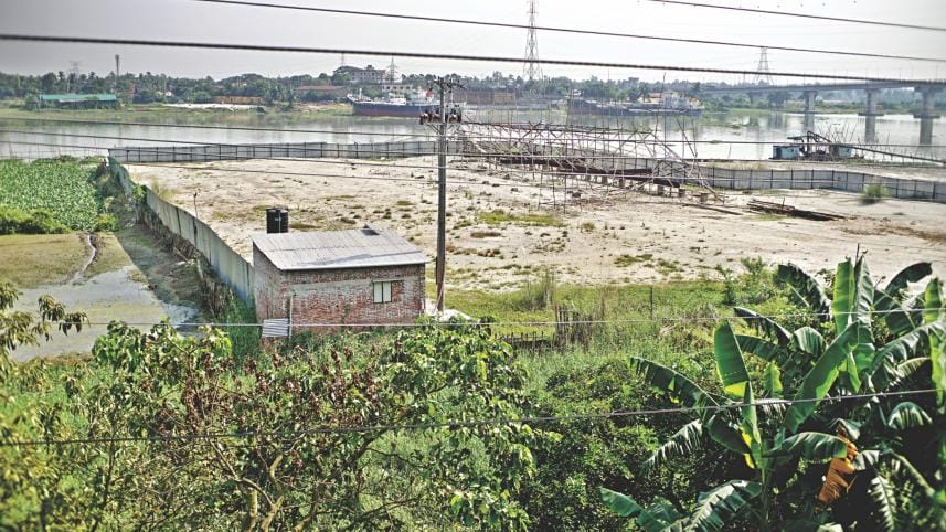
A large portion of the Shitalakhya river in Majihna Nadirpar near the newly-built Dastagir Bridge is being encroached further in defiance of an HC order and in full view of all river custodians, who remain silent. Photo: Rashed Shumon

What was once considered encroachment has become outright murder. But the seriousness of the crime has done little to deter a carnival of corruption plaguing river management.     

Despite an intervention by the High Court, the scenario has hardly changed.

In response to a public interest litigation over the slow death of the river Turag due to massive earth filling, an HC bench in early February this year ruled the waterbody be given the status of a living entity, making it a “legal entity”.

It was part of a 17-point directive by the court, which chalked out clear guidelines for saving the country’s rivers and wetlands from grabbing and pollution.

The directives paved the way for treating grabbing and polluting rivers as criminal offences and amending laws to empower the National River Conservation Commission as the legal guardian of all rivers. It also asked that all river grabbers be declared ineligible to contest elections and get bank loans.

The HC verdict came in line with yet another landmark HC judgement in 2009 that contained a nine-point directive for river conservation.  

Ten years later, however, most of the directives remain either unimplemented or implemented in a way that not only defeated the purpose of the judgement, but perhaps also harmed the rivers more.

Meanwhile, due to ruthless grabbing and toxic pollution of the four Dhaka rivers, there has been an acute crisis of drinking water in the capital city.

The Dhaka rivers have gotten narrower due to grabbing and hosting earth and sand filling, along with other structures. Siltation has also been a problem.

According to officials and conservation activists, in a sheer mockery of the country’s highest court’s landmark judgement on saving four rivers around the capital Dhaka, no key directive has yet been executed meaningfully.    

The most dramatic and significant example of this is how boundaries of four Dhaka rivers -- Buriganga, Shitalakhya, Turag and Balu -- have been demarcated, as it has actually legitimised further river grabbing.       

The 2009 asked the authorities to demarcate the rivers after surveys, set boundary pillars, publish a list of legitimate leaseholders of river land, evict grabbers, build walkways, plant trees and dredge the rivers and their sources.

Another directive was to hand over the rivers’ port limits to the authority concerned.

The survey was time-bound and set to be completed by November 2009. The boundary pillars and walkways had to be set up by November the following year.

The Turag river near Abdullahpur bridge is barely visible in the distance. All that can be seen is an encroached part, which somehow survived a BIWTA eviction drive a few months back. The photos were taken recently. Photo: Rashed Shumon

The apex court sin the judgement asked the relevant deputy commissioners of Dhaka, Narayanganj, Gazipur and Munshiganj, and the land record department to demarcate the rivers according to the Cadastral Survey (CS) records and Revised Survey (RS) records, whichever would make the rivers wider, to ascertain the original position of the rivers.

The DCs, however, neither followed the CS nor RS, let alone river laws, while surveying the rivers, said officials.

Ironically, the four rivers were officially narrowed in the name of demarcation, with boundary pillars wrongly installed during the dry season when the flow is lean.

The resurvey of the river area not only wasted public money, but extensive river foreshore area was excluded to encourage hundreds of fresh river grabbers, said officials.

Such surveys had been done on different rivers at different times, but the results hardly changed.

A FLAWED SURVEY

A serious flaw occurred in the process of river survey and demarcation, said Dr Muzibur Rahman Howlader, chairman of the National River Conservation Commission. 

“The DCs and Department of Land Records and Survey failed to realise the interests of the rivers and made mistakes,” he said, adding, “And in most cases, the river boundary has been demarcated wrongly, excluding existing river area.

“It appears the DCs and land record officials were either deficient in their knowledge of river- and land-related laws or did not have the courage to demarcate the rivers as per the law,” he said.

Revenue officials of the district administration might have randomly leased out river areas as land, and favoured influential coteries and private individuals, something the DCs could not undo while surveying the rivers, he said.  

“And the allegations of corruption in this process cannot be denied,” he said.

Syeda Rizwana Hasan, chief executive of Bangladesh Environmental Lawyers Association, a party to the writ petition that resulted in the 2009 verdict, said, “In most cases, the four Dhaka rivers have been wrongly demarcated, excluding inseparable river foreshores [and] actually narrowing the rivers officially.”   

The DCs and land record officials did not demarcate the rivers in accordance with how the court directed because it would expose the river grabbers.

The DCs have over the years leased out river foreshores to individuals.

“So, it was a kind of ‘moral duty’ for them and the land record officials to save the river grabber and not the rivers,” she said.     

The entire approach was tailored to protect the land in possession of the grabbers in the name of salvaging the rivers, and river-related laws were grossly ignored in the entire process, said a BIWTA official requesting anonymity.  

The classic example is the filling up of the Turag river under the very nose of half a dozen river custodians.       

As the primary job of river survey was grossly flawed, the very spirit of the judgement and directions for setting up boundary pillars, building walkways and tree plantation to protect the river banks have been frustrated, they said.

But where did it all go wrong? 

DEMARCATION GOES HAYWIRE

The then DC of Narayanganj admitted to this paper that they carried out the river survey only on the basis of RS records and did not take the river foreshores into consideration.

The district administration identified 3,010 illegal structures in the Shitalakhya river alone in the light of CS records, but the figure was merely 302 according to RS records and they adhered to the latter, said official sources.   

As a result, Shitalakhya became narrower than what it was in the 2001 joint survey maps prepared on the basis of CS records, said an official.

Since 2011, the deviation from the HC judgement was reported time and again.

According to an official estimate, the Shitalakhya river alone lost 1,857 acres (nearly 81 lakhs square feet) of area including 595 acres of foreshores and the rest from the river’s flowing waterway.

And in the four rivers, the area lost in the process of wrong demarcation, excluding the CS line, is estimated to be roughly no less than 5,000 acres, according to officials.  

In the same fashion, the Turag was mindlessly filled up with massive earth and sand filling during this decade nearly killing the river, an act that called for yet another HC judgement in February this year, giving the river the status of a “living entity”.     

Kamal Uddin Talukdar, the then DC of Gazipur, too admitted to this paper that they considered the Turag and Balu rivers’ flowing waterline as river area.  

The DCs and land officials ignored previous survey findings and drew the river line according to RS records which “generously accommodated river grabbing”, said an official of BIWTA requesting anonymity.

According to official correspondences, the controversial surveys were patchily completed in the four rivers by 2009 and early 2010.     

Though the BIWTA initially refused to sign such arbitrary survey reports, they finally relented, albeit with objections and the reports submitted to the court.

Narayanganj river port officials in 2010 wrote several times to Narayanganj DC expressing their dissatisfaction over the fact that the existing Shitalakhya river was made narrower in the process of survey but to no avail. 

In 2010 and 2011, the BIWTA’s Narayanganj river port officially repeatedly wrote to the Narayanganj district administration asking them not to narrow the existing Shitalakhya, and part of Buriganga and Balu rivers in the process of river survey on the basis of only RS records.

In a letter to the district administration, the port officials wrote that all four Dhaka rivers would have to be demarcated in pursuance of the CS records and this was not only according to the HC verdict but also the seventh meeting of national taskforce on river conservation on 16 May, 2010.

In particular, the BIWTA in the letter requested the district administration to demarcate the rivers in pursuance of the 2001 foreshore maps prepared and agreed on the previous joint survey of the district administration and BIWTA.

In 2011, on the basis of ground findings following the setting up of faulty demarcation pillars submitted to the Narayanganj district administration, the BIWTA wrote that at least 2,200 of over 4,000 pillars installed in Shitalakhya and part of Buriganga and Balu rivers under jurisdiction of Narayanganj river port were installed in the flowing water of the rivers. 

The action excluded an estimated 1,857 acres of existing rivers and they urged that those faulty pillars be reset 100 to 700 feet above the current position in the countryside just to save the rivers’ current water flow.

A port official, who then served in Narayanganj, said that the number of illegal occupants in the rivers under the Narayanganj river port area was 7,000 as per the CS records. The same number, however, was merely 700 as per RS records.

The district administration followed the latter record.

Similarly, the number of occupants was 4,000 as per CS records in the Buriganga under Dhaka river port, he said. It, however, was 400 as per RS records.

Mohibul Haque, the then DC of Dhaka, told this paper at the time of setting up of faulty pillars, excluding river foreshores, that the river survey had many flaws. 

A COSTLY UNDERTAKING

The government is set to discard all the 9,577 river boundary pillars installed during the last one decade since the judgement on the plea that those have either been wrongly placed, or are frail, displaced or broken.  

Against this backdrop, after a decade, the government has undertaken a Tk s2,300cr scheme for river conservation to reinstall 10,820 pillars all around Dhaka rivers discarding the old ones along 220 km banks of the 110-km long four rivers around Dhaka city. 

The project also includes dredging 1.7 cubic metre, excavating 70 lakh cubic metre, building 52kms walkways, 19 concrete jetties, 40kms key-wall along the river banks, three eco-parks and 409 benches.    

AKM Arif Uddin, BIWTA joint director and port officer of Dhaka River Port, said, “The new pillars will be stout and have longer life.”

The river survey was done sloppily, he said, adding, for example the BIWTA officially objected to 2,198 pillars in Shitalakhya and 1,192 of a total of 4,063 in the Buriganga, Turag and Balu.  

Terming the wrongly set up boundary pillars a tragedy, he said that the act of faulty demarcation encouraged hundreds of fresh grabbers to reclaim land in the flowing rivers.

With a resurvey of boundary pillars in Buriganga, Turag and Balu ongoing, the new three-year project is to be completed by June 2022, he said.

After a decade since the judgement of 2009, the aforementioned three-year project is by far the largest river-saving scheme that the government says it has undertaken to serve the purposes of the judgement.      

But the river commission Chairman Muzibur Rahman Howlader said that they have officially written to the authorities asking them to go ahead with the expensive projects only after ensuring demarcation of the river foreshores and flood plains.

The river resurvey with district administration, land records department, water development board, and BIWTA is still going on, he said.

The HC verdict in February also required authorities to obtain the river commission’s prior approval for implementing any river conservation project.

As for the river masterplans, Howlader said that he did not know much about the river experts who were formulating those.         

Among other components, the project also includes building 52km long walkway in addition to existing 22.5km, 37km river dredging, 19 concrete jetties, 40km key-wall for bank protection, forestation and three eco parks.

The home minister on July 6 inaugurated setting up of the fresh boundary pillars and building walkway and key-wall at Kholamora in Kamrangirchar. 

On the other hand, on July 21, the local government minister unveiled two decade-long masterplans to save the Buriganga, Turag, Balu, Dhaleswari and Pungli rivers, and the Karnaphuli and Halda rivers in Chattogram against grabbing and pollution, with the leading river conservationists knowing little about the content.  

LAWS THAT CAN HELP

It is not all doom and gloom. Restoring rivers to their original state is possible with the existing laws.

Muzibur Rahman Howlader, chairman of the river commission, said, “The river foreshore, which is a floodplain and wetland, must be reclaimed and conserved under the wetland conservation and water laws.”

In case of four Dhaka rivers, the embankment built by the water development board is an existing official river demarcation.

If for argument’s sake, any one owns land on the river foreshore, none can alter the character of it because it is an integral part of river and wetland, he said, adding any structures on the foreshore is a violation of several laws-- port act, inland shipping ordinance, wetland conservation act, water act and water development board act.

“It is a must to protect the hydrological boundary of a river,” he said. The hydrological boundary of a river is the expanse of a river’s water flow to the highest mark over the flood plain of foreshores during the monsoon.      

According to sections 86 and 87 of the State Acquisition and Tenancy Act, eroded part of a land holding in the river will remain part of river.

According to section 143 of the same act, deputy commissioners have the authority to cancel any private lease or ownership in the river.

Besides, the Land Appeal Board is empowered by the same law (section 149/4) to undo any fraudulent or wrong land record of river area in favour of private persons, he said.

None can harm the rivers, their navigable flow, water and riverine environment as the port act, inland shipping ordinance, wetland conservation act, environment conservation act, water act and the State Acquisition and Tenancy Act are all in place, said Howlader. 

The commission has requested Bangladesh Space Research and Remote Sensing Organization (SPARRSO) and River Research Institute to provide technological support to find the actual length and breadth of the four rivers. 

The laws applicable for saving rivers are Port Act, Port Rules of 1966, Inland Shipping Ordinance, Water Act, Wetland Conservation Act, Environment Conservation Act, State Acquisition and Tenancy Act, Land Manual.

Comments

বাংলাদেশে ইসলামি চরমপন্থার জায়গা হবে না: ড. ইউনূস

বাংলাদেশে আর কখনো ইসলামি চরমপন্থার জায়গা হবে না বলে মন্তব্য করেছেন অন্তর্বর্তী সরকারের প্রধান উপদেষ্টা ড. মুহাম্মদ ইউনূস।

৮ ঘণ্টা আগে