


Eastern coast sinking faster as sea level rises


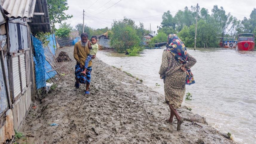
Bangladesh's eastern coast, a key zone for development activities, is sinking faster than the central and western coasts amid rising sea levels, posing threats to infrastructure, vast swathes of farmland and the livelihoods of millions of people, warns a new study.
The sea level along the Chattogram coastal plain in the east is rising by 4.73 millimetres a year, the highest rate in the country. In comparison, the sea level along the Sundarbans tidal plain in the west is climbing by 3.66mm and the Meghna estuarine floodplain in the central zone by 2.4mm a year.
 For all latest news, follow The Daily Star's Google News channel.
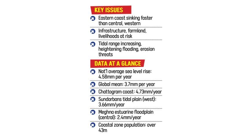
On average, the sea level along the country's coastline is increasing by 4.58mm annually, compared to the Global Mean Sea Level (GMSL) of 3.7mm -- the average height of ocean surface -- with land subsidence amplifying the threat in several regions, said the study published in the scientific journal Geomatics, Natural Hazards and Risk in August.
According to the Intergovernmental Panel on Climate Change (IPCC) report, the GMSL rise has accelerated since the late 1960s, with an average rate of 2.3 mm a year between 1971 and 2018. It increased to 3.7mm a year between 2006 and 2018.
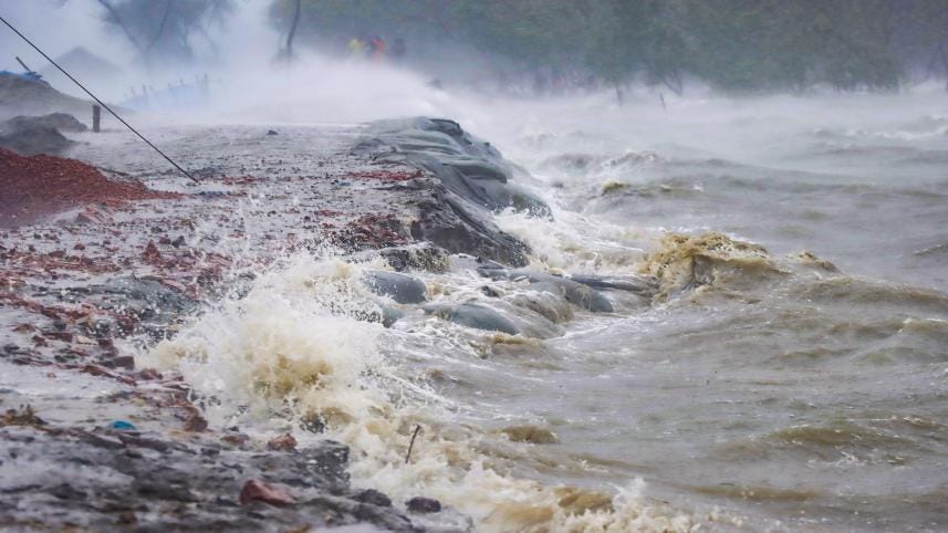
The study found that tidal range -- the gap between high and low tides -- is increasing, particularly in the east, raising the risk of flooding and erosion.
It also said Bangladesh witnesses distinct seasonal cycles, with sea levels typically peaking in April and dropping in September. These variations are driven by local conditions, including tidal dynamics, sediment flow, and land deformation.
The country's coastal zone, home to over 43 million people, sits just 1-1.5 metres above the sea level, meaning even modest rises over a short period could spell trouble for the region.
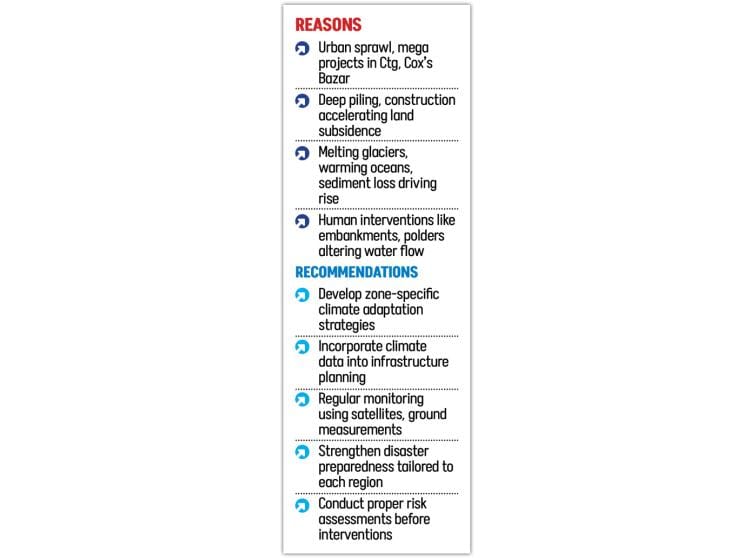
Explaining the contrast between the eastern and western coasts, Ashraf Dewan, the lead researcher of the study, said the eastern plains of Chattogram and Cox's Bazar are witnessing rapid urbanisation and large-scale infrastructural projects like the Matarbari Power Plant.
Construction and deep piling for these projects are contributing to subsidence in the region. Tidal range is also higher there, said Ashraf, also a professor at Curtin University in Australia.
By contrast, the western region, dominated by expansive mangrove forests, has seen less human intervention and lacks dense urban structures, with most of the land used for agriculture.
"In the west, the Sundarbans acts as a buffer, a natural shield… But in the east, most of the land is flat and vulnerable, apart from the hills," he told The Daily Star.
He also pointed out that a few areas, including Chattogram's Sadarghat and Teknaf are experiencing a land uplift as the eastern region is a tectonically active zone.
Ashraf said the findings carry urgent implications. "Since our infrastructure is not climate-resilient, many along the eastern coast will gradually be damaged and unusable in the future if the issue is not addressed immediately,"
He warned that farmlands could be submerged and crop yields may decline, endangering the livelihoods of millions.
THE FINDINGS
The study, titled "Estimating Vertical Land Motion-adjusted Sea level Rise in a Data-sparse and Vulnerable Coastal Region", drew on decades of tide gauge records, satellite altimetry, and radar-based remote sensing to measure the changes in both sea levels and vertical land motion.
It flagged changes in tidal range, which is increasing in many coastal areas. Amplified high tides mean greater risks of flooding and erosion, with the eastern coast showing the most pronounced effects.
Researchers noted that melting glaciers, warming oceans, groundwater extraction, sediment loss, and natural ground shifts are driving the rise, while monsoons and air pressure changes cause short-term fluctuations.
Human interventions such as polders and embankments have further disrupted water flow, altered tidal patterns, and reshaped sediment movement, they added.
CALL FOR LOCALISED ACTION
Stressing the need for localised solutions, Ashraf said, "Our combined data on land subsidence and sea level rise highlight an urgent need for targeted climate adaptation and infrastructure planning in vulnerable regions like Bangladesh.
Blanket policies will not work in a landscape where sea level rise, land motion, and tidal behavior vary widely, Ashraf said, calling for regular satellite and ground monitoring.
"When infrastructure is designed, climate information must be incorporated at the planning stage. Otherwise, at some point, it will no longer withstand the pressure," he said, adding that disaster preparedness and climate adaptation strategies should also be tailored to the unique conditions of each zone.
Nandan Mukherjee, director at Binks Sustainability Institute in the UK, said that risk assessment remains a missing link.
He said the authorities must first measure and assess risks before taking any steps, especially for those working at the grassroots level.
"One of our biggest knowledge gaps is that we often confuse risk with vulnerability. The first and most essential task is to identify where the risks are, the level at which they exist, and the timeframe over which they may pose a threat -- only then can we respond appropriately," added Nandan, also a teacher at the University of Dundee in the UK.
Comments