Views

How well can we deal with landslides?
Although landslides are a natural occurrence due to rainfall, recent landslides in Bangladesh have primarily been triggered by human activities.
Landslides in Bangladesh
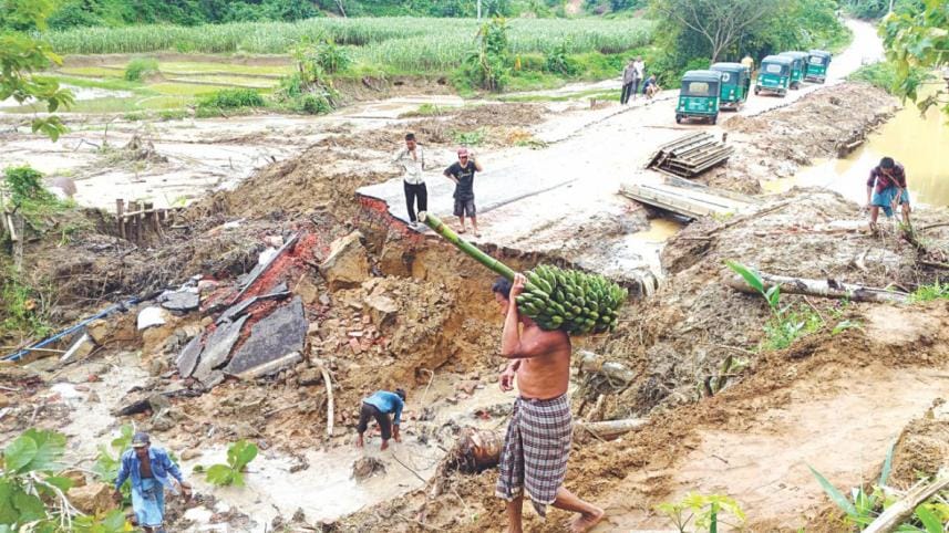
The Chattogram hill districts are very likely to face catastrophic landslides during the monsoon seasons. Unfortunately, Bangladesh is not yet prepared to deal with landslide disasters. FILE PHOTO: STAR/Anvil Chakma/Mohammad Ali Jinnat

Although landslides are a natural occurrence due to rainfall, recent landslides in Bangladesh have primarily been triggered by human activities. In 1968, landslides were first observed due to damage to the then Kaptai-Chittagong road. The five hilly districts of Chattogram division – Bandarban, Chattogram, Cox's Bazar, Khagrachhari, and Rangamati – were significantly affected. 

Research has shown that between 1990 and 2010, deforestation took place in nearly 1,130 sq-km of the five hilly districts, and approximately 420 sq-km of land has been transformed into urban areas, indicating extensive hill-cutting.


Notable reasons behind landslides in Bangladesh include construction of settlements without proper planning, cutting down of forests and trees, construction of unplanned settlements on risky slopes, conversion of hills into plots and flats, inappropriate forest management, lack of appropriate cultural knowledge and skills to build houses on hills, population pressure, unplanned urbanisation, extraction of stones from hilly streams and foothills, and lack of coordination among relevant government, autonomous, and non-governmental institutions. 

Usually, two types of communities are found on the hills of Bangladesh. One group consists of Indigenous communities – who have lived in the mountains for centuries. The second group consists of local Bangalees, who have lived in these hills for almost a generation. Various information and evidence analyses show that the settlers, mainly Bangalees, face landslide risks. Bangalees living in densely populated urbanised areas (such as upazila sadar or large municipalities) are mainly from extremely poor sections. Due to a lack of adequate civic facilities, they are forced to live on risky slopes. Although most of the hills in Bangladesh are considered government-owned land, and cutting hills is prohibited, a specific class of people are haphazardly settling on these hills from different parts of the country. Within a radius of about half a kilometre, there are facilities such as jobs, adequate roads, schools, markets, banks, playgrounds, medical facilities, etc, which attracts countless low-income people, including climate migrants, towards these hills. 

The residents – usually garment workers, day labourers, drivers, shopkeepers, and small business owners – live in rented houses. Hundreds of thousands of people live at risk of landslides on these hills and regularly face various economic and social problems.

One noteworthy aspect of these hills is the cultural differences between the Bangalees and the Indigenous communities. The Indigenous people have traditional and deep-rooted cultural knowledge about which slope of the hills to build their homes on and what kind of materials to use. They also know how to cultivate and earn a living on the mountains and how to survive in a challenging environment. Their houses are built on bamboo stilts, and the roofs are thatched using bamboo leaves. These homes are not designed to withstand severe weather conditions, but are resilient against landslides. However, in recent years, the Chittagong Hill Tract (CHT) region has become vulnerable to landslides due to changes in Indigenous lifestyle and agricultural practices, illegal logging and stone extraction, construction of roads without sufficient geological surveys and slope stabilisation measures, promotion of unsustainable tourism, and lack of ecological restoration activities.

Given the overall context, the Chattogram hill districts are very likely to face catastrophic landslides during the monsoon seasons. Unfortunately, Bangladesh is not yet prepared to deal with landslide disasters.

In the three hill tract districts, landslides primarily occur in road-cut and hill-cut sections. Communities living in funnel-shaped locations surrounded by hills are marked as highly risky. This scenario is common for most of the hilly towns and municipalities in Bangladesh. 

Meanwhile, the Rohingya crisis has added another dimension to the landslide vulnerability in Cox's Bazar. Currently, the district is hosting over one million refugees who have faced serious crimes against humanity in Myanmar and fled to Bangladesh. A vast protected hilly forest was quickly converted into a mega-informal settlement by cutting hills and destroying forests. This changed the entire local forest ecosystem and hilly landscape. As a result, the Rohingya residing in the camps also face the risk of major landslides and flash floods every year. Similar landslide vulnerability also exists in other neighbouring upazilas and for host communities in Cox's Bazar. 

Given the overall context, the Chattogram hill districts are very likely to face catastrophic landslides during the monsoon seasons. Unfortunately, Bangladesh is not yet prepared to deal with landslide disasters. We do not even have national or regional landslide early warning systems (LEWS). Some organisations and academic institutions are trying to develop and introduce the country's first LEWS. However, those systems or technologies are still ineffective or have not gone through scientific validation and recalibration.

Landslides should be categorised as major human-made disasters. Detailed scientific research should be conducted on each hill's geographical, geological, topographical, geotechnical, soil, and land use aspects in those hilly districts. Using scientific methods, landslide hazard and risk maps for each upazila should be prepared to identify risky hills and communities at risk of landslides. Also, an effective LEWS should be introduced by integrating all four major components – risk knowledge, forecasting systems, dissemination and communication, and preparedness and response capacities. This will enable people living in vulnerable areas to evacuate to safe places days in advance of a potential landslide disaster.

We also need to assess the economic and social status of those living on the hills, with regular surveys conducted to analyse their dynamic social vulnerability. Furthermore, high-risk hill-dwelling populations in particular should be evacuated to shelters during the rainy season every year. Provisions for landslide shelters should be created, and vulnerable people should be given temporary residence there during periods of extreme rainfall. A comprehensive risk-sensitive land use plan should be produced and implemented for the hill districts in Chattogram, and the northeastern Sylhet region. The plan should include community-friendly anticipatory actions and a forecast-based financing mechanism, and promote nature-based solutions to tackle landslide disasters.

Finally, a permanent and high-level landslide task force should be formed under the leadership of the Ministry of Disaster Management and Relief, involving all key stakeholders such as the Bangladesh Meteorological Department, Bangladesh Space Research and Remote Sensing Organization, Geological Survey of Bangladesh, and other government, autonomous, non-government and intergovernmental organisations, community leaders, and the general public. 

Bayes Ahmed is an associate professor at the Institute for Risk and Disaster Reduction of the University College London (UCL).

Comments

How well can we deal with landslides?

Although landslides are a natural occurrence due to rainfall, recent landslides in Bangladesh have primarily been triggered by human activities.
Landslides in Bangladesh
The Chattogram hill districts are very likely to face catastrophic landslides during the monsoon seasons. Unfortunately, Bangladesh is not yet prepared to deal with landslide disasters. FILE PHOTO: STAR/Anvil Chakma/Mohammad Ali Jinnat

Although landslides are a natural occurrence due to rainfall, recent landslides in Bangladesh have primarily been triggered by human activities. In 1968, landslides were first observed due to damage to the then Kaptai-Chittagong road. The five hilly districts of Chattogram division – Bandarban, Chattogram, Cox's Bazar, Khagrachhari, and Rangamati – were significantly affected. 

Research has shown that between 1990 and 2010, deforestation took place in nearly 1,130 sq-km of the five hilly districts, and approximately 420 sq-km of land has been transformed into urban areas, indicating extensive hill-cutting.


Notable reasons behind landslides in Bangladesh include construction of settlements without proper planning, cutting down of forests and trees, construction of unplanned settlements on risky slopes, conversion of hills into plots and flats, inappropriate forest management, lack of appropriate cultural knowledge and skills to build houses on hills, population pressure, unplanned urbanisation, extraction of stones from hilly streams and foothills, and lack of coordination among relevant government, autonomous, and non-governmental institutions. 

Usually, two types of communities are found on the hills of Bangladesh. One group consists of Indigenous communities – who have lived in the mountains for centuries. The second group consists of local Bangalees, who have lived in these hills for almost a generation. Various information and evidence analyses show that the settlers, mainly Bangalees, face landslide risks. Bangalees living in densely populated urbanised areas (such as upazila sadar or large municipalities) are mainly from extremely poor sections. Due to a lack of adequate civic facilities, they are forced to live on risky slopes. Although most of the hills in Bangladesh are considered government-owned land, and cutting hills is prohibited, a specific class of people are haphazardly settling on these hills from different parts of the country. Within a radius of about half a kilometre, there are facilities such as jobs, adequate roads, schools, markets, banks, playgrounds, medical facilities, etc, which attracts countless low-income people, including climate migrants, towards these hills. 

The residents – usually garment workers, day labourers, drivers, shopkeepers, and small business owners – live in rented houses. Hundreds of thousands of people live at risk of landslides on these hills and regularly face various economic and social problems.

One noteworthy aspect of these hills is the cultural differences between the Bangalees and the Indigenous communities. The Indigenous people have traditional and deep-rooted cultural knowledge about which slope of the hills to build their homes on and what kind of materials to use. They also know how to cultivate and earn a living on the mountains and how to survive in a challenging environment. Their houses are built on bamboo stilts, and the roofs are thatched using bamboo leaves. These homes are not designed to withstand severe weather conditions, but are resilient against landslides. However, in recent years, the Chittagong Hill Tract (CHT) region has become vulnerable to landslides due to changes in Indigenous lifestyle and agricultural practices, illegal logging and stone extraction, construction of roads without sufficient geological surveys and slope stabilisation measures, promotion of unsustainable tourism, and lack of ecological restoration activities.

Given the overall context, the Chattogram hill districts are very likely to face catastrophic landslides during the monsoon seasons. Unfortunately, Bangladesh is not yet prepared to deal with landslide disasters.

In the three hill tract districts, landslides primarily occur in road-cut and hill-cut sections. Communities living in funnel-shaped locations surrounded by hills are marked as highly risky. This scenario is common for most of the hilly towns and municipalities in Bangladesh. 

Meanwhile, the Rohingya crisis has added another dimension to the landslide vulnerability in Cox's Bazar. Currently, the district is hosting over one million refugees who have faced serious crimes against humanity in Myanmar and fled to Bangladesh. A vast protected hilly forest was quickly converted into a mega-informal settlement by cutting hills and destroying forests. This changed the entire local forest ecosystem and hilly landscape. As a result, the Rohingya residing in the camps also face the risk of major landslides and flash floods every year. Similar landslide vulnerability also exists in other neighbouring upazilas and for host communities in Cox's Bazar. 

Given the overall context, the Chattogram hill districts are very likely to face catastrophic landslides during the monsoon seasons. Unfortunately, Bangladesh is not yet prepared to deal with landslide disasters. We do not even have national or regional landslide early warning systems (LEWS). Some organisations and academic institutions are trying to develop and introduce the country's first LEWS. However, those systems or technologies are still ineffective or have not gone through scientific validation and recalibration.

Landslides should be categorised as major human-made disasters. Detailed scientific research should be conducted on each hill's geographical, geological, topographical, geotechnical, soil, and land use aspects in those hilly districts. Using scientific methods, landslide hazard and risk maps for each upazila should be prepared to identify risky hills and communities at risk of landslides. Also, an effective LEWS should be introduced by integrating all four major components – risk knowledge, forecasting systems, dissemination and communication, and preparedness and response capacities. This will enable people living in vulnerable areas to evacuate to safe places days in advance of a potential landslide disaster.

We also need to assess the economic and social status of those living on the hills, with regular surveys conducted to analyse their dynamic social vulnerability. Furthermore, high-risk hill-dwelling populations in particular should be evacuated to shelters during the rainy season every year. Provisions for landslide shelters should be created, and vulnerable people should be given temporary residence there during periods of extreme rainfall. A comprehensive risk-sensitive land use plan should be produced and implemented for the hill districts in Chattogram, and the northeastern Sylhet region. The plan should include community-friendly anticipatory actions and a forecast-based financing mechanism, and promote nature-based solutions to tackle landslide disasters.

Finally, a permanent and high-level landslide task force should be formed under the leadership of the Ministry of Disaster Management and Relief, involving all key stakeholders such as the Bangladesh Meteorological Department, Bangladesh Space Research and Remote Sensing Organization, Geological Survey of Bangladesh, and other government, autonomous, non-government and intergovernmental organisations, community leaders, and the general public. 

Bayes Ahmed is an associate professor at the Institute for Risk and Disaster Reduction of the University College London (UCL).

Comments