9 rivers cross danger line

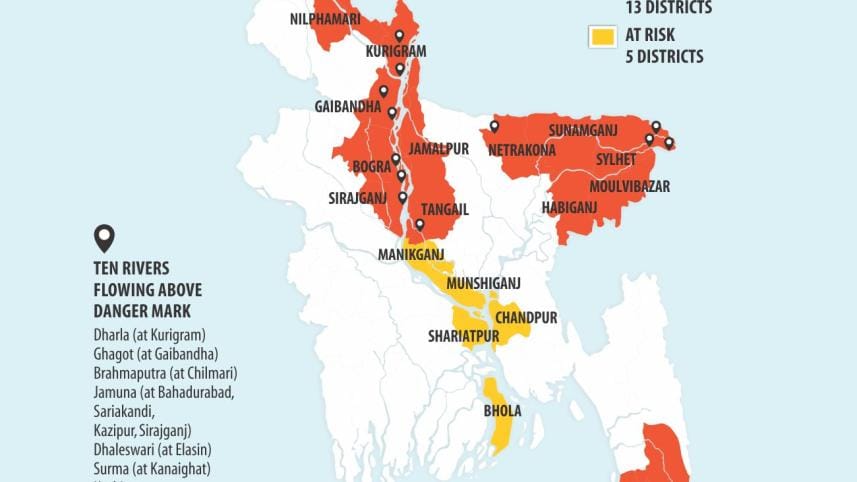
At least nine rivers, including the Jamuna, Teesta, Dharla, Surma and the Kushiyara, are flowing above the danger level, but experts say that will neither worsen nor prolong the current flooding.
However, there is a possibility of a fresh flood if it rains heavily in the northeastern states of neighbouring India, they add.
The water level of the Jamuna (the Brahmaputra in India) began to rise on June 30 and the swelling river caused floods in the northern region. But the water will flow down to the central part of the country in a day or two.
“The situation is likely to improve," said Sazzad Hossain, executive engineer of the Flood Forecasting and Warning Centre.
"There is a forecast of heavy rains in India but the flood situation in the northern region of Bangladesh may not get worse as there was no heavy downpour in Assam in the last two days.”
Ruling out a prolonged or heavy flooding in a week or two, he said the Brahmaputra keeps swelling but the water level of the Ganges is far below the danger mark.
"The flood situation in the country would turn worse if the water levels of the Brahmaputra and the Ganges cross the danger mark simultaneously. But the Ganges is currently flowing four metres below the line."
However, it is hard to say what will happen in August or September as the forecasting centre is not able to make projections beyond one week based on the available data.
The situation will largely depend on how much it rains in the upstream of the Ganges basin in the coming days, Sazzad Hossain said.
India Meteorological Department has warned of heavy rains this monsoon in a number of Indian states, including Assam, Arunachal Pradesh and West Bengal, raising the possibility of a fresh deluge.
There is also a forecast of heavy downpour in northeastern states of India, including Mizoram, Monipur, Sikkim, Tripura and Bihar.
Downpours in all these states would directly affect northern Bangladesh as the water would roll down to that region through the Jamuna and the Teesta.
Dhaka Met office said there is no forecast of long-term heavy rain in Bangladesh. But there will be “normal downpours” in August and September.
Many rivers that stream down to the Bangladesh plains from the northeastern states of India are fed with heavy rains this year. Within just three weeks of the start of this monsoon season, an early flood occurred in Sylhet region and another flood in the northern region.
The situation in the Sylhet region started to improve as the water of the Surma and Kushiyara receded a few days back. But their levels are again on the rise.
Out of 90 observing stations in the country, 70 show rising trends with water flowing above the danger level at 14 points.
In Assam, heavy showers in the upstream caused severe flood for the last few weeks inundating 20 districts and affecting thousands of people.

However, Bangladesh will not see a massive flooding like that of 1998 or 1988, said Dr Rashed Chowdhury, climatologist at the Pacific ENSO Applications Climate Centre, University of Hawaii.
"I think Bangladesh will experience a normal or slightly above normal flooding in 2017,” he said.
In a “normal flood”, at least 30,000 square kilometres of area is inundated, experts say. The current flood affected 13 districts, including five in the northern region, but it is still “below normal”.
Rashed, who has been doing research on El Nino and La Nina and long-term flood forecasting method, said Bangladesh's flood is highly correlated with strong La Nina event which is not present at the moment.
El Nino and La Nina are complex weather patterns caused by variations in ocean temperatures in the Equatorial Pacific.

 For all latest news, follow The Daily Star's Google News channel.
Comments