In Focus

Environmental history of Dhaka: An outline
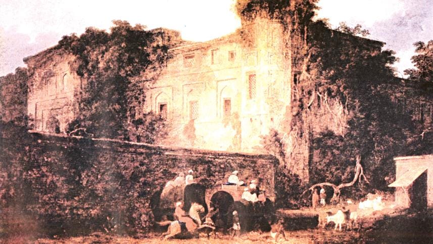
The Great Kuttra, Dacca. Oil on canvas, 60 x 89 cm, circa 1811. Artist: Charles D’Oyly. Provenance: Eyre & Greig, 1988. Private collection. Courtesy: Charles Greig.

Environment has been key to Dhaka's birth and rebirth, growth and development as well as its urban predicaments. Recently, Dhaka's environmental issues have led to public debates drawing a lot of interest. However, there has been no long-term historical trajectory in such debates, despite the fact that many of the contemporary environmental issues could be appreciated from a historical perspective.

Environmental changes in Dhaka

It has been suggested that in the Mughal period, especially during Shaista Khan's time (1663-79), Dhaka was one of the largest cities in the world. Although it is usually believed that Dhaka thrived only along the banks of river Buriganga until 1905, there are reasons to believe that during the Mughal period, it extended up to rivers Tongi, or Turag. We have no clear idea about the internal environmental dynamics of those times, but it seems that not only river Buriganga, but other surrounding rivers and internal canals were maintained and kept well as these worked as both commercial and commuting arteries.

Thomas Bowrey's narratives of Dhaka's environment from the late seventeenth century offer some observations which would sound quite interesting today. The book pointed to the fact that the sea was closer to the city and had brackish water, which was the "only inconvenience". On the authority of French scholar and traveller Thevenat, Bowrey noted that "the tide comes up as far as Dacca, so that the Galleys which are built there may easily trade in gulf of Bengala, the Dutch makes most use of it for their commerce..." The second significant point that Bowrey made was the proximity of the river, perhaps the Buriganga, that ran "close by the wall thereof" and which, to his word, was a "fine convenience" – its water being "extraordinary good" that relieved the brackishness of the city water table. Another more significant function of the river, which was 40 miles in length, was that it was remarkably navigable, being able to sustain ships weighing 500-600 tonnes.
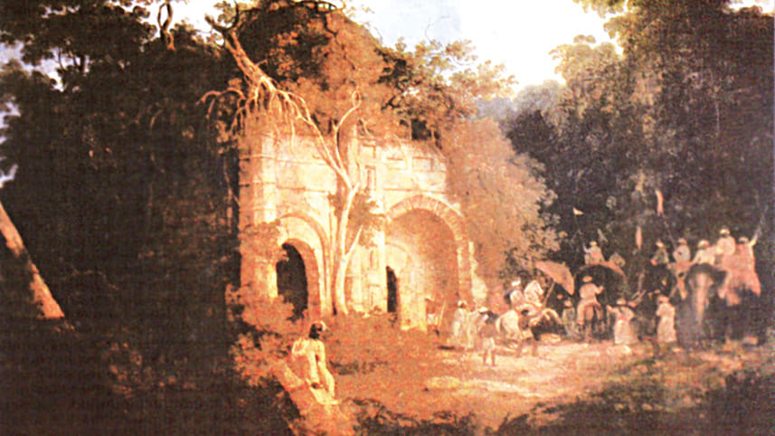
Mosque in the suburbs of Dacca. Oil on canvas, 60 x 89 cm, circa 1812. Artist: Charles D’Oyly. Provenance: Eyre & Greig, 1988. Private collection. Courtesy: Charles Greig.

If the proximity of rivers and the sea made Dhaka a suitable candidate for an emporium and urban settlement in colonial times, it was not until the 1850s, as mentioned earlier, when Dhaka's fortunes were revived. The question, however, remains to what extent the revival of Dhaka contributed to the environmental changes of the city. At least we can trace some data with which we can compare the changes that took place subsequently. For instance, according to Taylor's account, Dhaka's underground water level varied in the range of 18-22 feet in the 1830s, "according to the depth of the super-stratum of alluvial soil and to the height of the rivers." In the year 1836, noon time temperature in Dhaka was 78.6 (25.75 Celsius). As Taylor observed, the abundant wind with moisture, sweeping over the surface of the large rivers and the swamps, mitigated the heat, "rendering the climate cool and pleasant during April to July." Or the fact that the Dholai Khal connected as late as the mid-nineteenth century the River Baloo with the river Buriganga, rendering drainage possible for the city. Or the fact that river Buriganga was about half a mile in breadth as late as the 1880s.

If compared to the present time, there are clear indications that water level has gone down and mean temperature has risen significantly. At present the water level has gone down to 140-160 feet, while the current mean temperature appears to be at 89 (31.7 Celsius). There clearly is a strong relationship between the decline or loss of rivers and wetlands in and around Dhaka and the city's rising temperature.

Despite the fact that Dhaka lost its status as capital in the late Mughal period and was devastated by famine and flood in the late eighteenth century, the British seemed to have appreciated the importance of the river Buriganga for a considerable part of their rule. The East India officials moved into the Lalbagh Fort and built a residence nearby. An overall appreciation of the commercial need of the river contributed to the proper upkeep of the same. This added aesthetic value to the city itself. As Taylor describes: "The city stands upon the northern bank of the Boorigonga about eight miles above its confluence with the Dullaserry. The river, which is here deep and navigable, by large boats, expands in the season of inundation to a considerable breadth, and gives to Dacca with its minarates and spacious buildings, the appearance, like that of Venice in the west, of a city rising from the surface of the water."

However, as the railway began to expand, the water system fast declined as a commercial nerve line. With the focus away from river Buriganga the internal smaller streams and canals that worked as tributaries of the river Buriganga and other surrounding rivers also fell victim to the expansion northward. "The great change came in the 1880s with the railway which was drawn along what at that time were the outskirts of the city. In this way the city turned its face towards land, and the banks of the river began to lose their economic importance and social status." By the turn of the century, the British apparently had environmental settings around its buildings. The first houses in Ramna were set in "real wilderness". The race course was built. The government buildings were placed south of it and a "very spacious" garden suburb with white bungalows for civil servants was laid out north of it. In fact, the Dhaka of the early 20th century preceded Delhi.
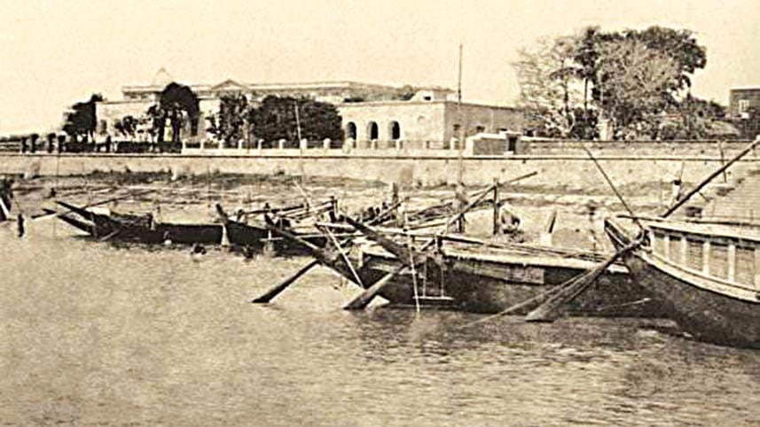
Buriganga River (1880). Photo: Collected

As Nilsson puts it: "The new Dacca was a general rehearsal for the expansion of Delhi that was undertaken a few years later." Yet it might well be assumed that much of the wetlands disappeared during the construction of the "British Dhaka". The expansion of Dhaka away from the river Buriganga in the early 20th century began the first process of environmentally insensitive developments of Dhaka. The trend continued in the Pakistan period. In the post-1947 era, when Dhaka saw the growth of a series of industrial suburbs, especially at Tejgaon, the city core by the river was "allowed to fall into a state of decay". The project of Ayub Nagar or the second capital (Sher-e-Bangla Nagar, which now forms an administrative nerve-line of the city), which included the construction of Louis Kahn's famous parliament building, came at a considerable cost of the loss of wetland. So if the British recreated some of the forest landscape, in the Pakistan period, some water flow was recreated around 'Avub Nagar'. These truly represented Eastern Bengal's picturesque forested and watery landscape, but these modernist physical developments did not reflect the basic principles of built environment. These were examples of artistic modernity of representation of nature rather than integration with it. After independence, Dhaka's environmental situation was left to deteriorate along with many other urban facilities.

While environmental changes in Dhaka have taken place for the worse, particularly so at the beginning in the early nineteenth century due to man-made reasons, one needs to be alert to the reality of natural disasters as well. In 1775 and 1812, there were severe earthquakes. The 1872 earthquakes, which occurred on 10th April and 11 May, caused the destruction of several houses and public buildings in the city and the then outskirts of Tejgaon. A severe tornado in 1888 destroyed parts of the Nawab family's palace including members of the stall who were with the Nawab family in the evening of the storm. More than 100 bodies were found in the city, but many more feared dead. More than 1,200 were wounded. Nine large mansions were completely demolished and about 150 were severely damaged. More than 3,500 kuchta houses were uprooted, 120 large boats and many smaller ones including a steamer of the Nawabs were sunk and destroyed. The damage done to property inside the city was estimated at about 70,000 pound sterling. These are some examples in the course of the nineteenth century that show that Dhaka city was not immune from natural disasters. If we take 1840 as a starting point, Dhaka has grown enormously in population since then, when its population was about 70,000. If any powerful natural disaster like earthquake and tornado takes place in our time, the damage would be colossal.

Environmental perceptions and consciousness

In an article published in the journal All the Year Round, edited by Charles Dickens, the author describes the Ganges in the following words:

"FROM the mountains covered with eternal snow to the ocean basking in the rays of the tropical sun flows Gunga, the river. By Mahommedan mosque and palace; by Hindoo temple and serai: by European factory and English guardhouse; while all around is ever shifting; while men and manners come and go; while those that today cool their parched throats, or leave their weary limbs, or sport in idleness in its cool and limpid stream, tomorrow float helpless on its bosom, hewn down by the sword of the invading warrior, or victims of a cruel superstition; unchanged since history began, the river flows on unchanging still."

The author has proved wrong. The Ganges, so as other rivers, have changed. Rivers do indeed change. But what is surprising is that the consciousness about rivers and riverine landscape has changed too. Bangladesh's environment in general and Dhaka's waterscape in particular have become clear victims of our unconsciousness. For example, on 7th February 2010, the much-awaited dredging programme began in the grossly polluted river Buriganga. This spell of cleaning campaign, which came into being as a result of civil society pressure, aimed to extract over 3,000 tonnes of waste in three months. But news articles reported in the following days that while dredging was taking place at one point of the river, tonnes of garbage were being dumped on many other points. This certainly reflects the problem of environmental management in a populous country like Bangladesh, but it also glaringly speaks of a general fault-line in our environmental consciousness. Dhaka's history is so much the history of a city in tryst with its environment, especially water. Yet, neither romanticism nor pragmatism places Dhaka's environment securely in our consciousness. How do we explain this?

In the colonial times, the changing environmental relations were informed by new security concerns, new technology and new pace of international trade. It meant that the ecological setting of the Bengal delta was no longer informing the spatial growth, emergence or shifting of the city of Dhaka. Rather it would be the official perception of the ecology of the region that would influence the environmental conditions of Dhaka.

The colonial government wanted to keep the peasant resistance under control and it was increasingly becoming clear that river police were not adequate to stem influence and mobility of the resisting peasants like the Faraizis and the so-called dacoits who had established a very efficient river network of transport and communication. Secondly, given the pace at which jute was being produced and carving a niche in the world market, the commercial elite and the government were looking for swifter transport to the ports. While in 1828 the export value of Bengal jute was just about 70 pounds, by 1873, it was worth 4 million pounds. The opening of the Suez canals reduced the distance between London and the Bay of Bengal by about 4,000 miles and this reduction of distance in the global marketplaces meant that the internal transport system had to keep pace with this. It was therefore no wonder that the intricate river and water system would be made the scapegoat for a more "speedy" surface transport network. And it was about this time the railways were making their way in Bengal which was not going to exist in harmony with the water regime.

The combination of these broad factors led to the fashioning of a certain consciousness that was hostile to the fluid riverine ecology of the region. This anti-deltaic consciousness can be summarised by a colonial official's remarks in the late nineteenth century. After criticising the disadvantages of boat travels which depended on the tides, the author writes:

“Carannigons” (Keraniganj) and “Damerah” (Demra), c. 18th century (National Archives, The Hague: Vosmaer family map collection (access code 4.VMF), inv. no. 848, plate 36, f. 46). Courtesy: Bengal Institute

"The crew insisted on stopping for their midday meal in a muddy stream between high banks, where the vertical sun of May or June warmed the boat like an oven, and not a breeze tempered the heat. Violent showers of rain compelled the closing of all the windows and occasionally threatened to swamp the pinnace. From the attacks of river Dacoits or pirates, the Englishman, of course, enjoyed immunity, and native merchants were often glad to avail themselves of his safe convoy...in hot weather or rains it was simply a penace. The traveller has to put up with heat confinement, slow progress, and the chance of being drowned, or at least of losing all his goods and chattels on a sandback in a "north-wester." The boatman would sleep when the passenger wanted to get on and when he wanted to sleep they would jabber about their domestic affairs, and sing in monotonous and exasperating tones some fearful vernacular ditty about a Sahib's boat with oars painted red, a boatman who chewed betel, and a Brahman's daughter who had come down to the riverside. It was but small comfort under such circumstances to recollect that the plague mosquitoes, and the croaking frogs, and the song of boatmen, and the unpardonable delay, had all been endured and immortalized on a not so dissimilar journey undertaken by a Roman poet just eighteen hundred years before."

If a Roman poet was settling in the consciousness of a colonial official in the late nineteenth century Bengal, this official's consciousness in turn has perhaps travelled forward to many who have been governing the environment in the postcolonial times.

In the Pakistan period, an appalling ecological unconsciousness surpassed even that of the British. The first master plan for Dhaka, drafted in 1958 by Minoprio & Spencely and P.W., included a provision for "green belts". However, as it was being revised by 1967 the then D.I.T's Chairman Abul Khair suggested "cutting out a great deal of area originally designated as green belt and making development recommendations instead." This is a deviation from even the least environmental consciousness that the British administration showed about Dhaka.

Referring back to our starting point of the massive cleaning project of the river Buriganga and simultaneous process of pollution, we would suggest that given the flawed nature of our environmental consciousness, any such efforts may not be fully successful. In our own time, there are two specific aspects of this false consciousness.

Firstly, such efforts are often taken place in piecemeal, rather than being informed by the broader environmental problems across the Delta that have trans-regional and trans-national dimensions. The fate of Dhaka's rivers is integrally bound with that of the major trans-boundary rivers. So the problems of Dhaka rivers and those of the entire country, have to be taken up holistically.

Secondly, we need to appreciate the ecological commons and to ensure the public sense of belonging to such commons. If the ecosystem services like clean water for everyday use, fish or water transportation routes are encroached upon for private gains, ordinary people will only find it a great pleasure to dump their waste as well as anger on such ecological resources.

Thirdly, another way of restoring ecological stability of Dhaka, particularly its water regime, is to make the surrounding rivers of Dhaka its high street. The cleaning and the upkeep of Dhaka river are not a favour or kindness to the rivers, but rivers are automatically kept well if their commercial and trade value is restored as has been the case for centuries.

Fourthly, a section of the civil society is taking it to satisfy the aesthetics of a river view. This is an important ingredient to environmental consciousness, but these ecological aesthetics have to be linked with more material base of the water system.

Fifthly, the river Buriganga and other surrounding rivers in Dhaka have to be the central nerve system rather than the peripheral boundary. It has to live not only in our consciousness, but in our everyday life. The absence of such process gives us clues to the question of why Dhaka thrived while its waterscapes were left to decline.


Iftekhar Iqbal is a faculty member, Faculty of Arts and Social Sciences, University of Brunei Darussalam.

This is an excerpt of the article titled 'Environmental History of Dhaka: An Outline' which was originally published in 400 years of Capital Dhaka and Beyond: Vol III, Urbanization and Urban Development (Asiatic Society of Bangladesh, 2011).

Comments

Environmental history of Dhaka: An outline

The Great Kuttra, Dacca. Oil on canvas, 60 x 89 cm, circa 1811. Artist: Charles D’Oyly. Provenance: Eyre & Greig, 1988. Private collection. Courtesy: Charles Greig.

Environment has been key to Dhaka's birth and rebirth, growth and development as well as its urban predicaments. Recently, Dhaka's environmental issues have led to public debates drawing a lot of interest. However, there has been no long-term historical trajectory in such debates, despite the fact that many of the contemporary environmental issues could be appreciated from a historical perspective.

Environmental changes in Dhaka

It has been suggested that in the Mughal period, especially during Shaista Khan's time (1663-79), Dhaka was one of the largest cities in the world. Although it is usually believed that Dhaka thrived only along the banks of river Buriganga until 1905, there are reasons to believe that during the Mughal period, it extended up to rivers Tongi, or Turag. We have no clear idea about the internal environmental dynamics of those times, but it seems that not only river Buriganga, but other surrounding rivers and internal canals were maintained and kept well as these worked as both commercial and commuting arteries.

Thomas Bowrey's narratives of Dhaka's environment from the late seventeenth century offer some observations which would sound quite interesting today. The book pointed to the fact that the sea was closer to the city and had brackish water, which was the "only inconvenience". On the authority of French scholar and traveller Thevenat, Bowrey noted that "the tide comes up as far as Dacca, so that the Galleys which are built there may easily trade in gulf of Bengala, the Dutch makes most use of it for their commerce..." The second significant point that Bowrey made was the proximity of the river, perhaps the Buriganga, that ran "close by the wall thereof" and which, to his word, was a "fine convenience" – its water being "extraordinary good" that relieved the brackishness of the city water table. Another more significant function of the river, which was 40 miles in length, was that it was remarkably navigable, being able to sustain ships weighing 500-600 tonnes.

Mosque in the suburbs of Dacca. Oil on canvas, 60 x 89 cm, circa 1812. Artist: Charles D’Oyly. Provenance: Eyre & Greig, 1988. Private collection. Courtesy: Charles Greig.

If the proximity of rivers and the sea made Dhaka a suitable candidate for an emporium and urban settlement in colonial times, it was not until the 1850s, as mentioned earlier, when Dhaka's fortunes were revived. The question, however, remains to what extent the revival of Dhaka contributed to the environmental changes of the city. At least we can trace some data with which we can compare the changes that took place subsequently. For instance, according to Taylor's account, Dhaka's underground water level varied in the range of 18-22 feet in the 1830s, "according to the depth of the super-stratum of alluvial soil and to the height of the rivers." In the year 1836, noon time temperature in Dhaka was 78.6 (25.75 Celsius). As Taylor observed, the abundant wind with moisture, sweeping over the surface of the large rivers and the swamps, mitigated the heat, "rendering the climate cool and pleasant during April to July." Or the fact that the Dholai Khal connected as late as the mid-nineteenth century the River Baloo with the river Buriganga, rendering drainage possible for the city. Or the fact that river Buriganga was about half a mile in breadth as late as the 1880s.

If compared to the present time, there are clear indications that water level has gone down and mean temperature has risen significantly. At present the water level has gone down to 140-160 feet, while the current mean temperature appears to be at 89 (31.7 Celsius). There clearly is a strong relationship between the decline or loss of rivers and wetlands in and around Dhaka and the city's rising temperature.

Despite the fact that Dhaka lost its status as capital in the late Mughal period and was devastated by famine and flood in the late eighteenth century, the British seemed to have appreciated the importance of the river Buriganga for a considerable part of their rule. The East India officials moved into the Lalbagh Fort and built a residence nearby. An overall appreciation of the commercial need of the river contributed to the proper upkeep of the same. This added aesthetic value to the city itself. As Taylor describes: "The city stands upon the northern bank of the Boorigonga about eight miles above its confluence with the Dullaserry. The river, which is here deep and navigable, by large boats, expands in the season of inundation to a considerable breadth, and gives to Dacca with its minarates and spacious buildings, the appearance, like that of Venice in the west, of a city rising from the surface of the water."

However, as the railway began to expand, the water system fast declined as a commercial nerve line. With the focus away from river Buriganga the internal smaller streams and canals that worked as tributaries of the river Buriganga and other surrounding rivers also fell victim to the expansion northward. "The great change came in the 1880s with the railway which was drawn along what at that time were the outskirts of the city. In this way the city turned its face towards land, and the banks of the river began to lose their economic importance and social status." By the turn of the century, the British apparently had environmental settings around its buildings. The first houses in Ramna were set in "real wilderness". The race course was built. The government buildings were placed south of it and a "very spacious" garden suburb with white bungalows for civil servants was laid out north of it. In fact, the Dhaka of the early 20th century preceded Delhi.

Buriganga River (1880). Photo: Collected

As Nilsson puts it: "The new Dacca was a general rehearsal for the expansion of Delhi that was undertaken a few years later." Yet it might well be assumed that much of the wetlands disappeared during the construction of the "British Dhaka". The expansion of Dhaka away from the river Buriganga in the early 20th century began the first process of environmentally insensitive developments of Dhaka. The trend continued in the Pakistan period. In the post-1947 era, when Dhaka saw the growth of a series of industrial suburbs, especially at Tejgaon, the city core by the river was "allowed to fall into a state of decay". The project of Ayub Nagar or the second capital (Sher-e-Bangla Nagar, which now forms an administrative nerve-line of the city), which included the construction of Louis Kahn's famous parliament building, came at a considerable cost of the loss of wetland. So if the British recreated some of the forest landscape, in the Pakistan period, some water flow was recreated around 'Avub Nagar'. These truly represented Eastern Bengal's picturesque forested and watery landscape, but these modernist physical developments did not reflect the basic principles of built environment. These were examples of artistic modernity of representation of nature rather than integration with it. After independence, Dhaka's environmental situation was left to deteriorate along with many other urban facilities.

While environmental changes in Dhaka have taken place for the worse, particularly so at the beginning in the early nineteenth century due to man-made reasons, one needs to be alert to the reality of natural disasters as well. In 1775 and 1812, there were severe earthquakes. The 1872 earthquakes, which occurred on 10th April and 11 May, caused the destruction of several houses and public buildings in the city and the then outskirts of Tejgaon. A severe tornado in 1888 destroyed parts of the Nawab family's palace including members of the stall who were with the Nawab family in the evening of the storm. More than 100 bodies were found in the city, but many more feared dead. More than 1,200 were wounded. Nine large mansions were completely demolished and about 150 were severely damaged. More than 3,500 kuchta houses were uprooted, 120 large boats and many smaller ones including a steamer of the Nawabs were sunk and destroyed. The damage done to property inside the city was estimated at about 70,000 pound sterling. These are some examples in the course of the nineteenth century that show that Dhaka city was not immune from natural disasters. If we take 1840 as a starting point, Dhaka has grown enormously in population since then, when its population was about 70,000. If any powerful natural disaster like earthquake and tornado takes place in our time, the damage would be colossal.

Environmental perceptions and consciousness

In an article published in the journal All the Year Round, edited by Charles Dickens, the author describes the Ganges in the following words:

"FROM the mountains covered with eternal snow to the ocean basking in the rays of the tropical sun flows Gunga, the river. By Mahommedan mosque and palace; by Hindoo temple and serai: by European factory and English guardhouse; while all around is ever shifting; while men and manners come and go; while those that today cool their parched throats, or leave their weary limbs, or sport in idleness in its cool and limpid stream, tomorrow float helpless on its bosom, hewn down by the sword of the invading warrior, or victims of a cruel superstition; unchanged since history began, the river flows on unchanging still."

The author has proved wrong. The Ganges, so as other rivers, have changed. Rivers do indeed change. But what is surprising is that the consciousness about rivers and riverine landscape has changed too. Bangladesh's environment in general and Dhaka's waterscape in particular have become clear victims of our unconsciousness. For example, on 7th February 2010, the much-awaited dredging programme began in the grossly polluted river Buriganga. This spell of cleaning campaign, which came into being as a result of civil society pressure, aimed to extract over 3,000 tonnes of waste in three months. But news articles reported in the following days that while dredging was taking place at one point of the river, tonnes of garbage were being dumped on many other points. This certainly reflects the problem of environmental management in a populous country like Bangladesh, but it also glaringly speaks of a general fault-line in our environmental consciousness. Dhaka's history is so much the history of a city in tryst with its environment, especially water. Yet, neither romanticism nor pragmatism places Dhaka's environment securely in our consciousness. How do we explain this?

In the colonial times, the changing environmental relations were informed by new security concerns, new technology and new pace of international trade. It meant that the ecological setting of the Bengal delta was no longer informing the spatial growth, emergence or shifting of the city of Dhaka. Rather it would be the official perception of the ecology of the region that would influence the environmental conditions of Dhaka.

The colonial government wanted to keep the peasant resistance under control and it was increasingly becoming clear that river police were not adequate to stem influence and mobility of the resisting peasants like the Faraizis and the so-called dacoits who had established a very efficient river network of transport and communication. Secondly, given the pace at which jute was being produced and carving a niche in the world market, the commercial elite and the government were looking for swifter transport to the ports. While in 1828 the export value of Bengal jute was just about 70 pounds, by 1873, it was worth 4 million pounds. The opening of the Suez canals reduced the distance between London and the Bay of Bengal by about 4,000 miles and this reduction of distance in the global marketplaces meant that the internal transport system had to keep pace with this. It was therefore no wonder that the intricate river and water system would be made the scapegoat for a more "speedy" surface transport network. And it was about this time the railways were making their way in Bengal which was not going to exist in harmony with the water regime.

The combination of these broad factors led to the fashioning of a certain consciousness that was hostile to the fluid riverine ecology of the region. This anti-deltaic consciousness can be summarised by a colonial official's remarks in the late nineteenth century. After criticising the disadvantages of boat travels which depended on the tides, the author writes:

“Carannigons” (Keraniganj) and “Damerah” (Demra), c. 18th century (National Archives, The Hague: Vosmaer family map collection (access code 4.VMF), inv. no. 848, plate 36, f. 46). Courtesy: Bengal Institute

"The crew insisted on stopping for their midday meal in a muddy stream between high banks, where the vertical sun of May or June warmed the boat like an oven, and not a breeze tempered the heat. Violent showers of rain compelled the closing of all the windows and occasionally threatened to swamp the pinnace. From the attacks of river Dacoits or pirates, the Englishman, of course, enjoyed immunity, and native merchants were often glad to avail themselves of his safe convoy...in hot weather or rains it was simply a penace. The traveller has to put up with heat confinement, slow progress, and the chance of being drowned, or at least of losing all his goods and chattels on a sandback in a "north-wester." The boatman would sleep when the passenger wanted to get on and when he wanted to sleep they would jabber about their domestic affairs, and sing in monotonous and exasperating tones some fearful vernacular ditty about a Sahib's boat with oars painted red, a boatman who chewed betel, and a Brahman's daughter who had come down to the riverside. It was but small comfort under such circumstances to recollect that the plague mosquitoes, and the croaking frogs, and the song of boatmen, and the unpardonable delay, had all been endured and immortalized on a not so dissimilar journey undertaken by a Roman poet just eighteen hundred years before."

If a Roman poet was settling in the consciousness of a colonial official in the late nineteenth century Bengal, this official's consciousness in turn has perhaps travelled forward to many who have been governing the environment in the postcolonial times.

In the Pakistan period, an appalling ecological unconsciousness surpassed even that of the British. The first master plan for Dhaka, drafted in 1958 by Minoprio & Spencely and P.W., included a provision for "green belts". However, as it was being revised by 1967 the then D.I.T's Chairman Abul Khair suggested "cutting out a great deal of area originally designated as green belt and making development recommendations instead." This is a deviation from even the least environmental consciousness that the British administration showed about Dhaka.

Referring back to our starting point of the massive cleaning project of the river Buriganga and simultaneous process of pollution, we would suggest that given the flawed nature of our environmental consciousness, any such efforts may not be fully successful. In our own time, there are two specific aspects of this false consciousness.

Firstly, such efforts are often taken place in piecemeal, rather than being informed by the broader environmental problems across the Delta that have trans-regional and trans-national dimensions. The fate of Dhaka's rivers is integrally bound with that of the major trans-boundary rivers. So the problems of Dhaka rivers and those of the entire country, have to be taken up holistically.

Secondly, we need to appreciate the ecological commons and to ensure the public sense of belonging to such commons. If the ecosystem services like clean water for everyday use, fish or water transportation routes are encroached upon for private gains, ordinary people will only find it a great pleasure to dump their waste as well as anger on such ecological resources.

Thirdly, another way of restoring ecological stability of Dhaka, particularly its water regime, is to make the surrounding rivers of Dhaka its high street. The cleaning and the upkeep of Dhaka river are not a favour or kindness to the rivers, but rivers are automatically kept well if their commercial and trade value is restored as has been the case for centuries.

Fourthly, a section of the civil society is taking it to satisfy the aesthetics of a river view. This is an important ingredient to environmental consciousness, but these ecological aesthetics have to be linked with more material base of the water system.

Fifthly, the river Buriganga and other surrounding rivers in Dhaka have to be the central nerve system rather than the peripheral boundary. It has to live not only in our consciousness, but in our everyday life. The absence of such process gives us clues to the question of why Dhaka thrived while its waterscapes were left to decline.


Iftekhar Iqbal is a faculty member, Faculty of Arts and Social Sciences, University of Brunei Darussalam.

This is an excerpt of the article titled 'Environmental History of Dhaka: An Outline' which was originally published in 400 years of Capital Dhaka and Beyond: Vol III, Urbanization and Urban Development (Asiatic Society of Bangladesh, 2011).

Comments

আমরা রাজনৈতিক দল, ভোটের কথাই তো বলব: তারেক রহমান

তিনি বলেন, কিছু লোক তাদের স্বার্থ হাসিলের জন্য আমাদের সব কষ্টে পানি ঢেলে দিচ্ছে।

৯ ঘণ্টা আগে