Back Page

Jamuna erodes part of Tangail embankment
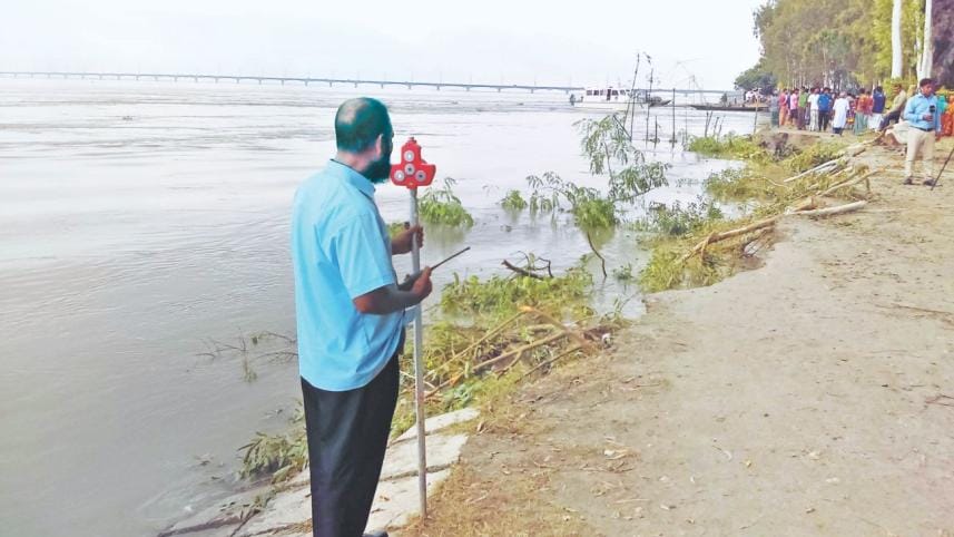
A man surveys the embankment on the eastern bank of the Jamuna for erosion in Gorilabari of Tangail's Kalihati upazila yesterday. The river devoured about 40 metres of the embankment close to the Bangabandhu Bridge creating panic among locals. Photo: Mirza Shakil

With water level going down in the Jamuna, erosion has damaged a portion of the village protection embankment on the eastern side of Bangabandhu Multipurpose Bridge at Gorilabari in Tangail's Kalihati upazila. 

Locals now fear that river water may inundate their localities. 

Erosion hit the embankment, located around 1.5km south of the bridge, on Tuesday afternoon, devouring about 30 metres of the embankment, said sources at Bangladesh Bridge Authority (BBA) yesterday.

On August 20, around 10 metres of the embankment also eroded into the river, they said. 

The BBA constructed the 200-metre village protection embankment, which was not in the main construction plan of the bridge, with geo-textiles, stone and concrete blocks during the bridge maintenance in 2003. It was built near the confluence of the Jamuna and Dhaleswari rivers to protect BBA's land and nearby localities from river erosion, they said.

Underwater sand was first washed away due to strong current in the water, and then the geo-textiles, stone and concrete blocks collapsed, they added.

There was no need to worry about the bridge as the erosion happened far away from the bridge, said Wasim Ali, assistant engineer at the site office of BBA in Tangail.

"After the collapse of 10 metres of the embankment on August 20, an expert team from consultant firm Institute of Water Modelling (IWM) examined the damage on August 21. They later informed us that the damage is not a threat to the bridge," he said.

"We have already informed the higher authorities about the fresh damage, and two teams from the BBA conducted a fresh survey on the damage," he said.

"The consultants from the IWM will re-examine the damage, and later steps will be taken as per their suggestions," he added.

Talking to this correspondent yesterday morning, locals blamed illegal sand lifting near the embankment as the main reason for the erosion. 

Though sand lifting is banned within a 6km radius of the bridge, a syndicate of influential sand traders, having political clout, lifts sand very close to the bridge, they alleged.

They also demanded immediate steps of the authorities concerned to check the erosion to protect the nearby villages.

The 5.63km Bangabandhu Multipurpose Bridge situated between Tangail and Sirajganj was built on the Jamuna for easing communications of northern and southwestern parts with other parts of the country, and it was opened for vehicular movement in 1998.

Comments

চট্টগ্রাম, দশ ট্রাক অস্ত্র আটক, লুৎফুজ্জামান বাবর, হাইকোর্ট,

১০ ট্রাক অস্ত্র মামলায় খালাস পেলেন বাবর

দশ ট্রাক অস্ত্র আটকের মামলায় সাবেক স্বরাষ্ট্র প্রতিমন্ত্রী লুৎফুজ্জামান বাবরসহ ছয় জনকে খালাস দিয়েছেন হাইকোর্ট।

৫১ মিনিট আগে