How Dhaka can restore its natural cooling system

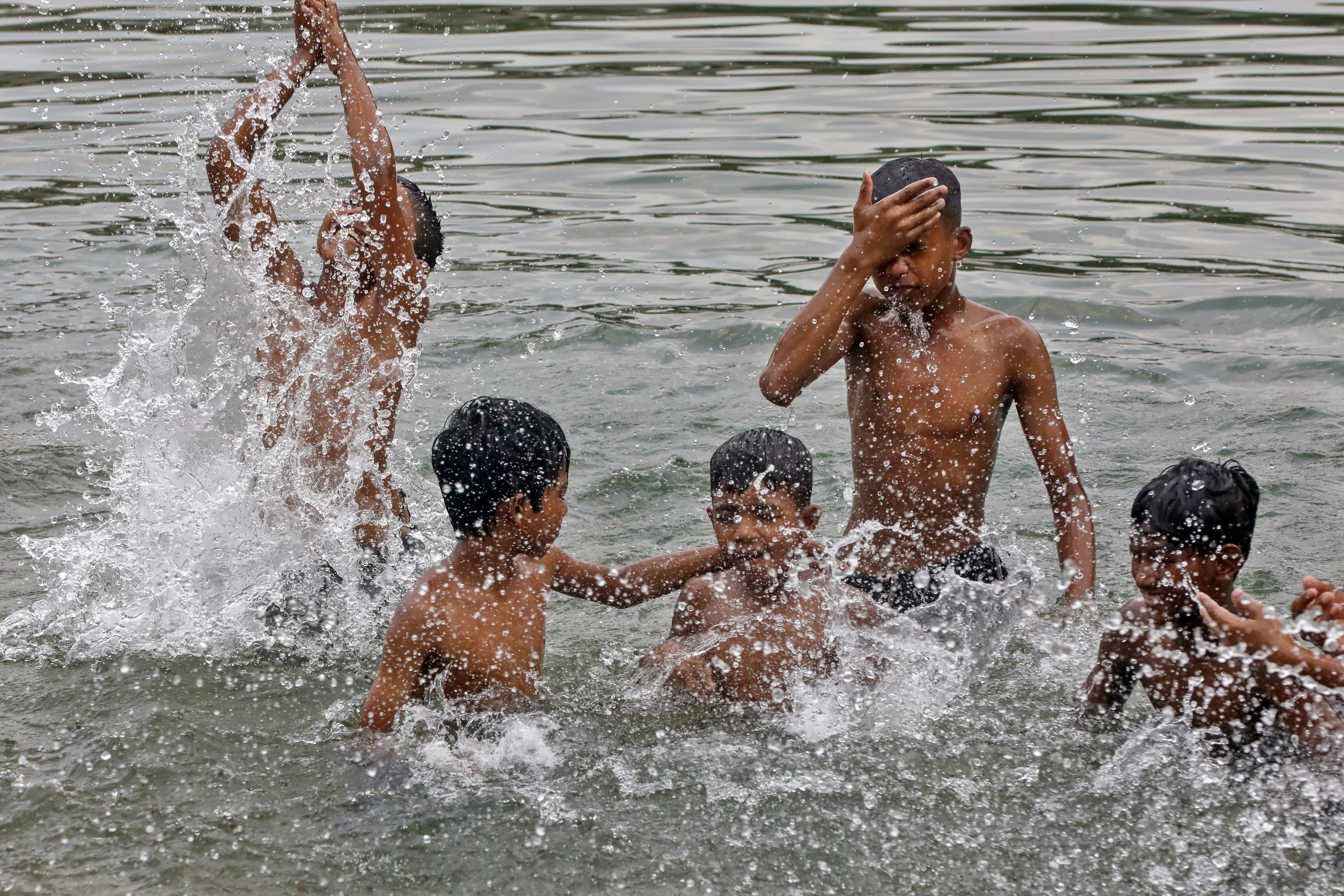
I was born in the Dhaka–Narayanganj–Demra (DND) agricultural project area. I witnessed how natural and man-made waterbodies, including canals, lakes, and large ponds, shaped the lives and livelihoods of hundreds of thousands of people. We swam, fished, and spent our leisure time in these vast waterbodies, especially during the monsoon, creating memories that remain unforgettable. I assume the same holds true for others who were born and grew up in different parts of the Dhaka megacity.
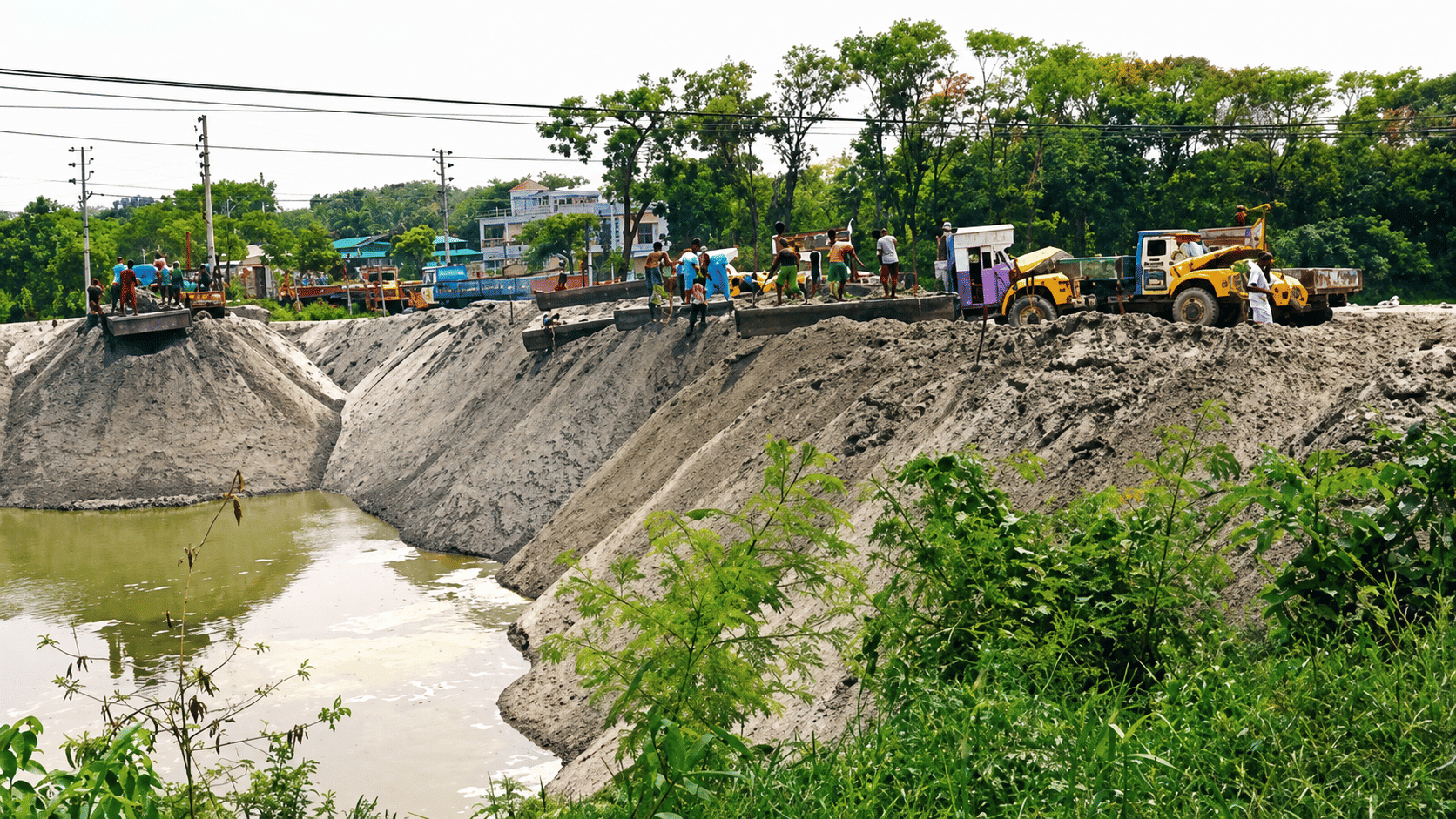
A visit to the DND area a year ago presented a gloomy and distressing picture. Most waterbodies have either been replaced by concrete or, where they survive, face severe threats from the growing demand for housing and infrastructure. People who once depended on these waterbodies for their livelihoods have changed professions and now struggle with declining incomes and other challenges. Waterbodies that once defined daily life, culture, and ecology have been lost to decades of unplanned urban growth. Their degradation and the fragmentation of Dhaka's blue network have left the capital hotter, more flood-prone, and environmentally fragile. The loss of ecosystem services associated with Dhaka's urban blue and green spaces has been estimated at around USD 200 million, reflecting the city's intense urbanisation.
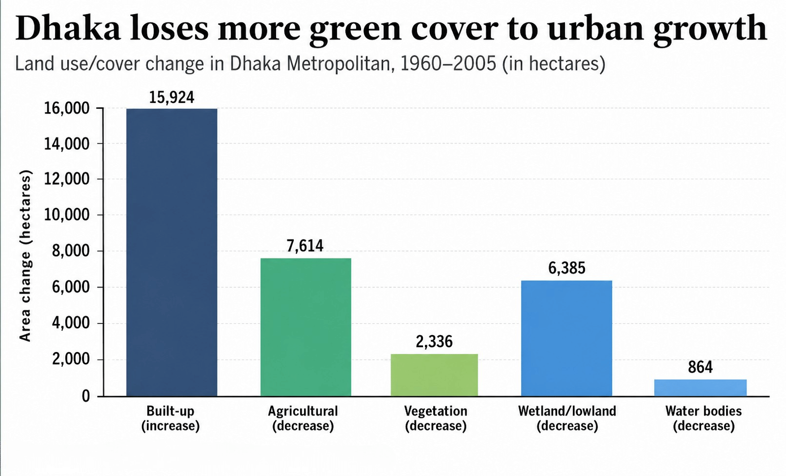
I have been researching environmental issues in Dhaka since 1999. My work has used historical maps, satellite imagery, and geographic information systems (GIS) to examine land-use change across the city. I found that the loss of waterbodies was neither accidental nor minor. We documented a remarkable expansion of built-up areas that consumed natural surfaces, including wetlands and waterbodies. Between 1960 and 2005, built-up areas increased by 160 km², while wetlands, lowlands, and waterbodies declined by 72.49 km² within the greater Dhaka area surrounded by four rivers: the Balu, Tongi Khal, Turag, and Buriganga. In other words, the city's growth came through the direct conversion of hydrologically important water-retaining features.
To understand the current status of waterbodies within the Dhaka Metropolitan Development Plan (DMDP) area, we used satellite images from 2014 to 2025. The investigation showed that the spatial extent of waterbodies had been significantly reduced, declining from 206 km² in 2014 to 140 km² in 2025. Much of this loss is attributable to the spread of built-up land, which increased from 206 km² in 2014 to 271 km² in 2025. This suggests that the conversion of water features into urban surfaces has not stopped. Various actors, including real-estate developers, continue to put pressure on waterbodies because they are often seen as readily available land for housing and infrastructure. Public policies intended to protect these features are either poorly implemented or largely ineffective.
Floodplains along the Balu River, for example, have been converted into residential land since 2000 despite existing planning and environmental regulations. River networks are narrowing due to weak enforcement, while natural canals have been turned into drains because of governance and political challenges. A similar pattern can be seen in western Dhaka, where, following the construction of flood-control embankments in the 1990s, the majority of waterbodies were filled to create housing and commercial spaces.
As waterbodies perform critical ecological functions, their steady disappearance has triggered a cascade of environmental consequences. Dhaka historically benefited from a natural gravity-drainage system because of its location within a floodplain landscape. Land-use change has weakened this natural flood-buffering capacity, aggravating flood hazards, as shown by our study.
A 2023 study paints an even bleaker picture, showing that the shrinking and encroachment of natural water features are likely to increase the duration of floods. Another study found that surface runoff in Dhaka could nearly double as a direct result of the land-use changes we documented earlier. Our recent work further confirms that rapid floodplain encroachment has increased flood risk across the country, and Dhaka is no exception.
Water has high thermal inertia, meaning it resists temperature change. During our childhood, urban warming was hardly a concern. Today, however, it has become a matter of grave concern. One of the most significant consequences of disappearing waterbodies is heat. These water features function as the city's most effective natural cooling system. The urban heat island (UHI) effect, defined as the temperature difference between urban and rural areas, has intensified considerably under rapid urbanisation.
Our study quantified Dhaka's surface UHI intensity using daytime and nighttime satellite data. The results showed that land surface temperature differences across the city are becoming increasingly pronounced. Between 2000 and 2019, Dhaka's daytime surface UHI intensity increased from 2.20 °C to 3.18 °C, a rise of 0.98 °C over two decades. The city recorded the largest daytime increase, with a long-term warming trend of 0.062 °C per year.
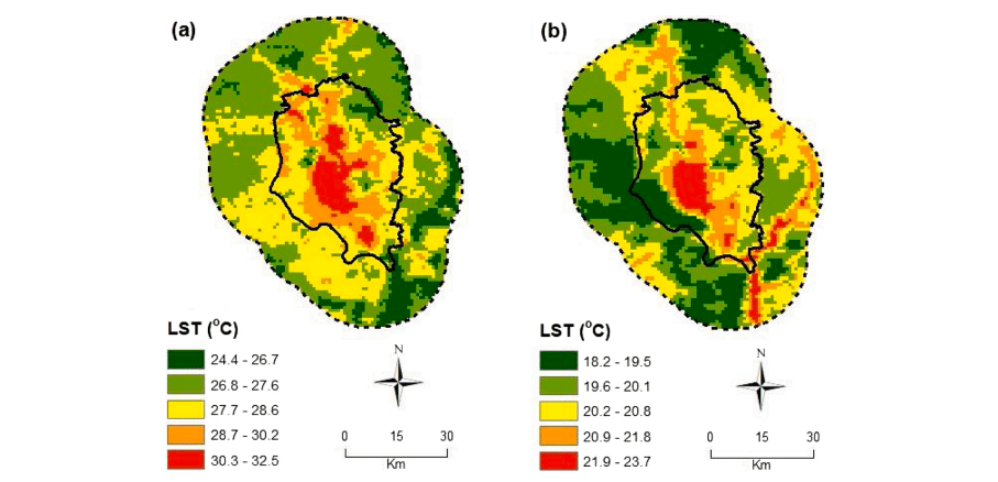
Similar patterns are seen in the canopy-layer heat island, which measures differences in air temperature between natural surfaces (e.g., vegetation) and urban surfaces. As a result, residents consistently experience hotter conditions. While air conditioners are increasingly used to cool indoor environments, their widespread use is also believed to contribute to local warming over time. Our research demonstrates that anthropogenic land-use change is strongly linked to rising UHI intensity and that the loss of water features is one of the principal drivers. Once, these waterbodies functioned as natural air conditioners. Today, we rely on artificial cooling systems that are neither sustainable nor effective in mitigating long-term warming.
Dengue, a mosquito-borne disease, has also become a year-round challenge. Dhaka experienced a dengue outbreak in 1960, when the disease was known as “Dhaka fever”. Since 2000, however, dengue incidence has become a persistent urban problem across Bangladesh, including Dhaka. Our study on dengue and typhoid indicates that both flood and water-stress conditions can amplify disease risk, as waterbodies play a critical role in regulating urban hydrology. Their disappearance has gradually increased public health risks, although this link often goes unnoticed. Consequently, healthcare expenditures, particularly among marginal communities, are rising, further reducing quality of life.
Once, these waterbodies functioned as natural air conditioners. Today, we rely on artificial cooling systems that are neither sustainable nor effective in mitigating long-term warming.
Beyond these visible environmental problems lies a quieter crisis beneath the ground. Groundwater levels in Dhaka are declining by roughly 2 metres per year on average, with studies reporting annual declines of 1.5–2.1 metres across much of the metropolitan area and even higher rates in some locations. For centuries, the city's abundant water features supported aquifer recharge. When these features are filled in or encroached upon, the recharge capacity of aquifers declines significantly. This creates a dangerous urban paradox: the city experiences flooding during the monsoon yet remains water-stressed because its natural storage and recharge systems have been compromised. Both problems stem from the same land-use decisions.
Another overlooked consequence of rapid urbanisation is land subsidence. The increasing weight of buildings and concrete infrastructure can gradually cause the ground to sink. Dhaka continues to expand with high-rise buildings, skyscrapers, and transport networks, many of which are constructed on floodplains and low-lying land. The growing number of structures places greater pressure on the landscape. Evidence suggests that this process is already underway. Data from a GNSS (Global Navigation Satellite System) station in Dhaka show that the city subsided at a rate of 12.7 mm per year between 2002 and 2020. If this trend continues, the city will face increasingly severe pluvial flooding. Increased spending on flood-control infrastructure alone cannot solve the problem.
What drives the disappearance of waterbodies? First and foremost is relentless demographic growth, which has fuelled enormous demand for housing. Second, Dhaka's role as the country's principal commercial and economic hub has intensified development pressures. Weak enforcement has also accelerated the loss of natural features. The role of planning and regulatory institutions, including RAJUK (Capital Development Authority), deserves careful scrutiny in relation to the loss of Dhaka's vast water networks.
Population growth is often blamed for the loss of blue spaces, but it does not justify ecological destruction. Cities such as Stockholm in Sweden and Perth in Australia demonstrate that water features can be integrated into urban expansion and can even enhance urban environments. We, however, chose the opposite path. Political interests have further weakened environmental governance. The growing politicisation of institutions has undermined regulation, while real-estate developers continue to exploit these governance failures. Equally important is the loss of our cultural connection with water. Earlier generations valued waterbodies as part of everyday life, but that attachment appears to have faded in an era of rapid urban expansion.
In our previous work, we argued that Dhaka's development model systematically undervalues ecological infrastructure because it does not generate immediate financial returns in the same way that apartments and commercial centres do. Yet nature keeps its own record, and when the time comes, it sends the bill. Rich or poor, citizen or politician, everyone eventually pays the price, knowingly or unknowingly.
Dhaka can still revive its water features. First, technology can help map these non-negotiable urban assets. Light Detection and Ranging (LiDAR) technology can accurately identify remaining canals, ponds, and other water features. These can then be restored by removing encroachments, reconnecting flow paths, and establishing protective buffer zones. Political will and strict enforcement, however, remain essential.
As many as thirty organisations influence Dhaka's development, yet poor coordination among them is widely acknowledged. We must improve coordination among land-use, drainage, housing, and environmental agencies, not rhetorically, but in practice. Water-sensitive urban design has become a defining concept in modern cities, and Dhaka must embrace it. This means increasing permeable surfaces, strengthening green-blue corridors, conserving floodplains, and aligning drainage systems with natural hydrology instead of destroying them for short-term gain.
We also need a cultural shift. We once had a pond within our residential compound in the DND area. Although small, it provided numerous ecological services, including cooling the neighbourhood, supplying water for domestic use, producing water hyacinth for fodder, and supporting periodic fish harvests. We recently filled it in to build a house after the land was divided among the owners.
Thousands of similar ponds once existed across Dhaka. We undervalued them and converted them for immediate benefit. The losses are immense and difficult to calculate, especially for a climate-vulnerable deltaic city. These waterbodies are frontline infrastructure for building climate resilience. Rather than viewing them through the lens of real-estate development, we must be willing to sacrifice short-term gains for long-term security.
We often blame climate change for chronic flooding, persistent waterlogging, rising urban temperatures, and the disappearance of native fish species. Rarely do we acknowledge our own role. We pursued short-term gains by filling waterbodies and replacing them with houses, commercial centres, and infrastructure. The costs of those decisions are now accumulating.
I have seen how the filling of even a small pond can create heat- and water-related problems. The question before us is simple: What kind of city do we want? Do we continue burying Dhaka's remaining waterbodies and spend ever more on healthcare, flood control, heat mitigation, and water supply? Or do we recognise these features as essential conditions for survival?
As climate change intensifies extreme events, Dhaka must plan not simply to grow, but to remain liveable for generations to come.
Ashraf Dewan is the Director of Research at the School of Earth and Planetary Sciences, Curtin University, Australia. He can be reached at a.dewan@curtin.edu.au.
Send your articles for Slow Reads to slowreads@thedailystar.net. Check out our submission guidelines for details.

Why technological progress isn't making us freer

Will Bangladesh's social security budget help the poor?

Should political parties be publicly funded?

Can outcome-based education survive the age of AI?

Remembering Ishaque Ali / When Bengalis stood up to racism in the UK

Bangladesh's cottage industries need more than nostalgia

Can a social media ban for children work in Bangladesh?
Why Bangladesh keeps suffering from an epidemic of bad projects
Big Picture / The long transformation of rural Bangladesh