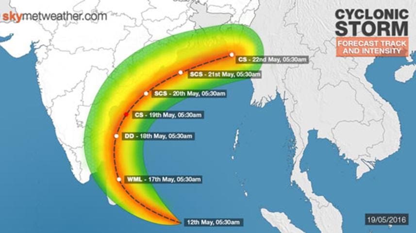
Cyclone Roanu heads towards Bangladesh

After battering the Indian coast for last two days, the first cyclone of the monsoon is heading north to Bangladesh.
According to weather forecasts, the cyclone is likely to make a landfall in Bangladesh in the next 48 hours.
The met office advised four maritime ports in Chittagong, Cox's Bazar, Mongla and Payra to hoist local warning signal No. 4 instead of 2 as cyclonic storm 'Roanu' over west-central bay and adjoining southwest bay moved slightly north-northeastwards over the same area.
It was centred at 12:00 noon (the 19th may 2016) about 1,365 kms southwest of Chittagong port; 1,335 kms southwest of Cox's Bazar port; 1,185 kms southwest of Mongla Port; and 1,215 kms southwest of Payra port, said a Met Office bulletin.
It is likely to intensify further and move in a north-northeasterly direction, the bulletin said.
As Roanu strengthens, waves in the Bay of Bengal could reach 6 metres in height and winds could briefly touch hurricane strength. This would make Roanu a severe tropical cyclone.
If the cyclone follows its present course, it might hit the coast on May 21 (Saturday) evening, Met Officer Abdul Mannan told The Daily Star.
It might also be weaker before the landfall, he added.
The maximum sustained wind speed within 54 kms of the storm centre is about 62 kph rising to 88 kph in gusts/squalls. The sea will remain very rough near the cyclone centre.
All fishing boats and trawlers over the North Bay and deep sea have been advised to remain close to the coast so that they can take shelter within a short notice. They are also advised not to venture into the deep sea.
Meanwhile, the disaster ministry this evening holds a special preparatory meeting with concern authorities for taking precautionary steps ahead of the Cyclone Roanu.


 For all latest news, follow The Daily Star's Google News channel.
Comments