To save Dhaka wetlands
Engr. M. Inamul Haque
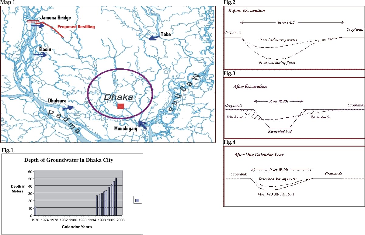
DHAKA City is located between latitudes 23040¢ and 23054¢ and longitudes 90020¢ and 90031¢ having total area of about 304.38 sq km. The city is bounded by the Balu and Sitalakhya rivers on the east, Tongi Khal on the north, Turag and Buriganga rivers on the west and Narayanganj district on the south. It lies at the southernmost tip of the Madhupur Tract, the central highlands of Bangladesh. Dhanmondi, Mirpur, Cantonment, Gulshan and Badda areas lie in this tract where many salban forests existed in the near past. In old days the Ganga and the Brahmaputra rivers met south of this city to form a combined flow towards the Bay of Bengal. Later the Brahmaputra shifted towards east and the Ganga changed its main course to other distributaries. Thus they left vast floodplains and lowlands to the east, west and south of the city. The floodplains to the west and east of the city have ground elevations 2 to 3 meters above mean sea level. Numerous beels, khals and creeks criss-crossed this land serving drainage and providing home for fishes and other aquatic animals. But in recent times, these lowlands are increasingly being filled up for housings, industries and commercial districts. The Dhaka industries are major polluters of the rivers and wetlands in and around the city, both by emissions and effluents. The industries at Tezgaon, Hazaribag, Tongi and Shyampur being located adjacent to the city centre are causing major harm to its environment. Information received from the Department of Environment reveal, tannery, cement, pulp, paper, sugar, textiles, food processing, engineering and chemical industries as well as fertilizer and pesticide factories are mostly responsible for this pollution. Presently the Dhaka WASA treats only 10 percent of the waste, the rest spills into the rivers through different channels. The Savar Export Processing Zone (EPZ) industries dump their untreated liquid waste into the Dholai Beel, the Bongshi River and the Dholai canal. These industries include electrical and electronics, footwear and leather goods, garment, dyeing, metal, paper goods, plastic goods and hardware. As a result of the polluted water, cultivation of boro crops is badly hampered and fishing in dry season in the whole length of Bangshi River has came to an end. The water of the Gulshan-Banani-Baridhara Lake has become stinky due to severe pollution. Sewage from the Badda, Baridhara, Gulshan and Banani residential areas and toxic discharges from the nearby industries have contaminated the water of the Banani and Gulshan lakes. All the garbage and toxic material are then washed down to the wetlands east of the city causing death to the fishes and aquatic animals. Dhaka WASA depends on the groundwater for 82 percent of its supply. This water is drawn by more than 400 deep tube wells of its own and more than 400 privately owned deep and shallow tube wells. The aquifers for the deep tube wells are the Pliocene age Dhupi Tila and the Dihing sandstone formations. The amount of water abstracted from groundwater for Dhaka City supply is about 1500 million liters per day. As the population and settlements are increasing, more and more water is drawn from the groundwater. It is observed that there is a persistent fall in Dhaka groundwater table. At the Consultancy Workshop on 'Dhaka City State of Environment' organised jointly by Dept. of Environment and Centre for Advanced Studies on 23 December 2004, it was revealed that, the Dhaka City groundwater level in 1970s was 11.3m, in 1996 26.6m, in 1997 28.15m, in 1998 30.45m, in 1999 31.85m, in 2000 34.18m, in 2001 37.78m, in 2002 42m, in 2003 46.24m and in 2004 50.60m average below the surface. (see Fig 1) Against this backdrop, I shall discuss a project taken up by the Bangladesh Water Development Board titled 'Augmentation of Buriganga Flow by Restoring Silted Up Links with Jamuna'. This project if implemented can bring additional flow in Buriganga during dry season. This shall reduce water quality deterioration in and around Dhaka, improve navigation and recreation, help groundwater recharge and check the wetlands from being dried up. But how much feasible is this project? Can this project be implemented? If implemented, can this project bring benefit for a single year? The project plans to remove silt for a considerable length from the Pungli river from its off take, to bring water from the Jamuna river. The Pungli is a branch of the Dhaleswari river. The Dhaleswari has two off takes from the Jamuna, one just dowstream of the Jamuna Bridge and the other at Bhara in Nagarpur Upazila of Tangail district. The off take 1 of the Dhaleswari river bifurcates immediately; the left branch named as the Pungli river flows southwest to meet first with the Bangshi river near Mirzapur, and then becomes the Turag river at Kaliakoir. The other branch flows south to meet with its off take 2 west of Elashin Ghat. The Dhaleswari then flows south, southwest to become the Kaliganga river near Manikganj and then again the Dhaleswari near Munshiganj. The feasibility of this project is primarily based on the fact that the Pungli has the only surface water flow that comes down over to Dhaka City through the Turag river. If augmented, the water can be distributed to the Buriganga river and Tongi Khal by gravitation flow. There are other four locations around Dhaka City where from augmentation to the rivers of Dhaka City can be contemplated. These are the Dhaleswari from Elashin, the Padma from Dhulsara, the Dhaleswari from Munshiganj and the Sitalakhya from Toke. But all these flows either bypasses the Dhaka City or need to be back lifted to reach this City (see Map1). But my question is, can this BWDB project be implemented? We had a similar project a few years back for augmentation of the Gorai river flow by clearing up silt from its off take, upto a considerable length. This project at the cost of around 350 crore taka was implemented in two consecutive years by dredgers, but resulted in total failure. Not only that, this project had a far reaching negative effect. If one travels over the Gorai Bridge 7 km east of Magura, he can observe that the river has shrinked, no erosion on either side, but encroachment of green fields towards the midline of the river. Why it happened? The dynamics of river morphology is such that if a silt carrying river does not get sufficient flow round the year, the silt deposited in the bed during falling floods cannot be removed totally by the monsoon flow in the following year. The flows of Old Brahmaputra, Dhaleswari and Gorai rivers are getting reduced every year leading to net deposit of silt at their off takes, and remain cut off from their feeders during low flows. Removal of silt from the off take of Gorai was thought to be the right step in the project but there was no space for disposal of the silt. People along the banks of Gorai were not ready to accept sand filling over their croplands to the loss of fertile topsoil. So, the dredged soil was deposited along the slopes of the river. This reduced the top width of the river immediately from its off take and changed the river morphology. This step could bring early inflow through this river in next monsoon, but silting did occur again in the next falling flood. It was suggested that the same amount of dredging be done every year to get the benefit. The project lasted for two years with similar dredging in the following year, but stopped in the third year for want of fund. The result of Gorai dredging was disastrous. I can anticipate similar disaster in case of Pungli river dredging if done at its off take. I see no skope of the excavated sand to be deposited on the adjacent croplands. So, they have to be laid on the river slopes (Fig. 2 &3). The Pungli is a narrow river compared to the Gorai river. One can imagine what it shall look like when 15 feet soil shall be excavated from the centre of the river and deposited on the slopes. This excavation shall not bring benefit immediately as it happened for Gorai river, where the Ganga river thalweg was very nearby. For Pungli river, further excavation of 1 km of Dhaleswari off take and not less than 5 km of Jamuna river shall be needed to link the perennial flow. And again this same quantity of excavation shall have to be repeated every year. If not, the river shall be filled up with silt in the falling flood resulting in a disaster (see Fig 4). Augmentation in silt carrying rivers without putting a diversion structure over the mother river is a hopeless concept. The Canal Digging Programme started in the late seventies to link dead khals with perennial source was successful only where the rivers were not carrying silt. The silt carrying rivers filled up the excavated canals very soon and there the attempts failed eventually. In those cases barrage could divert the water flow to the desired direction even in low flows. So, diversion of water through Pungli river can only be possible if a barrage is put on the Jamuna river just downstream of the Dhaleswari off take. It is contemplated that some sort of structural measures shall be taken at the Dhaleswari river off take to attract the flow towards the Pungli river round the year. One must keep in mind that the Jamuna river has average 6 km bed width at this point and its thalweg does not lie adjacent to the Dhaleswari off take. Any structural measure either in the form of establishing hard points or putting bottom vanes can have very much local effects only. It shall have no effect on the total behaviour of the river. The effect of such structures can be visualised in physical models. A mathematical model to understand this effect shall be misleading. But a physical model in this case cannot also give a sustainable solution unless the structural measure is supported by a diversion structure over the Jamuna river. With the above discussion we may arrive at a hopeless position to save our wetlands in and around Dhaka City. I understand closing our eyes on the perpetrators who defy laws by discharging untreated waste from their factories, encroach and grab public lands cannot lead us anywhere. It will be foolish to wait for a heavenly solution. But we must take some stringent measures to stop those perpetrators. I have the following suggestions. 1. Clear up all encroachments from the public khals and canals in and around Dhaka City. Stop all sorts of leasing process of public lands including the wetlands. Ban filling fertile top soils by carried sand. Direct the housing companies to excavate a pond in their project and fill the project area by its spoil. This shall create space for recreation and improve the environment. 2. Increase dependence on the surface water for the water supply of Dhaka City. The source should be the Turag and Sitalakhya rivers. Build 4 more water treatment plants at Narayanganj, Badda, Uttara and Mirpur. 3. Punish the perpetrators who discharge untreated waste from their industries in public khals. Recover the public khals from unauthorised encroachments. Build 6 more sewage treatment plants at Narayanganj, Demra, Badda, Uttara, Mirpur and Mohammadpur. 4. Demarcate the wetlands needed to maintain a healthy environment for the public in and around Dhaka City. Maintain these wetlands as done for the Dhanmondi Lake. Plant babla, neem, shal, shishu and other trees along edges of embankments and roads. Plant jam, tal, kadbel, kul, kanthal, chalta, gab, jalpai, dewa, khejur, narikel, supari and other trees along the slopes of embankments and roads. Engr. M. Inamul Haque is Director General, Bangladesh Haor & Wetlands Development Board.
|
|
