Dying rivers deliver deluge blow
25 dead or half-dead; route length shrinks to 3,800km from 24,000km
Pinaki Roy
Flooding recurs every year with spiralling ferocity, as no fewer than 25 of the 230 rivers in the country are either dead or dying out, with many more dozens drying up and reduced to water pockets, river experts say.Natural causes paired up with indiscriminate and ill-planned human interventions have been strangling the rivers, lifelines for many a towns and villages. Agriculture, transportation, trade and commerce, socio-economic development, environment and lifestyle of the localities are also changing accordingly. "Excessive siltation has been cutting down the water-bearing capacity of the rivers, which is why they now burst the banks more frequently and with less water flow than they did previously," notes Flood Control and Information Centre Director Dr Selim Bhuiyan. "So we suggest the government take measures to maintain navigability of rivers and stop encroachment on riverbeds." RIVERS IN DEATH THROES
Water Development Board (WDB) officials warn all the 25 rivers, parts of which have already turned into stagnant waters, will dry up completely in a few years. Farmers now cultivate crops in the dry riverbeds during the dry season of winter and spring. They also breed fish in the stagnating river areas. The WDB says these 25 vulnerable rivers once were connected with the three major river systems of the Ganges, the Jamuna and the Brahmaputra. But the water flow in the systems from upstream India started to dwindle decades ago, drying and sealing up their infalls or connecting points with the rivers. Continued deposition of silt, erosion of crop-field soil and massive encroachment as well as lack of dredging are some other major afflictions pushing these rivers to extinction, WDB officials say. "Mainly the tributaries and distributaries of these rivers are dying. Some of them because their infalls from the main rivers have been blocked and some others due to changes in their courses," says Mohammad Inamul Haque, director general at Bangladesh Haor and Wetlands Development Board. The total length of river courses in Bangladesh is approximately 20,000 kilometres, covering 9,770 square kilometres or 7 percent of the country's area. According to the river map of WDB, 54 of the country's 230 rivers flow down from India and three from Myanmar. Water experts say dams and barrages constructed upstream in India on most of these international rivers are choking the water flow to Bangladesh. The 17 rivers a WDB report terms dead are Narasunda (Kishoreganj), Bhubaneswar (Rajbari and Faridpur), Bibiyana and Shakha Barak (Habiganj), Palang (Shariatpur), Burinadi (Comilla and Brahmanbaria), Harihar and Mukteswari (Jessore), Hamkura (Khulna), Morichap (Satkhira), Bamni (Lakshmipur and Noakhali), Manos (Bogra), Baral and Chiknai (Natore and Pabna), Hisna (Kustia), Musakhan (Rajshahi and Natore) and Bhairab (Kushtia, Meherpur, Chuadanga, Jhenidah, Jessore, Khulna and Bagerhat). The rivers marked as near-dead are Karatoa (Panchagarh, Nilphamari, Rangpur, Bogra and Sirajganj), Ichhamati (Pabna, Manikganj, Dhaka and Munshiganj), Kaliganga (Kushtia, Jhenidah, Magura, Narail, Pirojpur), Kumar (Kushtia, Magura, Faridpur, Jehnidah, Madaripur), Chitra (Narail, Chuadanga, Jhenidah), Bhadra (Jessore, Khulna), Someshwari (Netrakona) and Nabaganga (Narail). The receding water flow has shrunken the ailing rivers to mere canals. Numerous chars have emerged in some main rivers. Salinity has increased in the coastal zone that threatens the Sundarbans, a world heritage site. Experts believe the top dying disease that affects the Sundari trees in a vast part of this world's largest mangrove forest is also caused by the increasing salinity in river water. IMPACT OF FARAKKA
A government source claims over 80 rivers have dried up in the last three decades due to the Farakka barrage built in 1974 on the Indian side of the Ganges, some 17 km off the border. Meanwhile, a super-ambitious plan of India to link up the major common rivers flowing from the Himalayas and to divert them to the drought-prone areas in the south is still on the drawing board. Bangladesh government scientists estimate that even a 10 to 20 percent decrease in the water flow to Bangladesh could dry out vast areas for much of the year, with 100 more rivers in the Ganges, Brahmaputra and Meghna basins also dying out. Some experts however say Farakka barrage cannot be held singularly responsible for the deaths of these rivers. They rather blame it also on a lack of river management. "The rivers from Noakhali, Sylhet and Dinajpur are not affected by Farakka [barrage]. These rivers dried up mainly because of lack of care," says Dr Ainun Nishat, country's leading river expert. "Rivers should be managed properly, as our country is flood-prone and a lot of siltation and soil erosion occur every year," Nishat says. "Just 50 years ago, farmers used to cultivate only two crops, Aman and winter vegetables. But now they are growing Boro, which causes more soil erosion and the eroded soil is ultimately discharged into the canals and rivers leading to filling up of river beds," he explains. CROPPED RIVER ROUTE
Over 15,600km of river routes across the country, meanwhile, have lost navigability because of continual silt deposition in the last 29 years, while another 3,300km routes have become risky for plying of riverine vessels. An official at Bangladesh Inland Water Transport Authority (BIWTA) says the total length of river courses was 24,000km in 1971. But in 1984 it came down to 8,400km during the rains and only 5,200km in the dry season. At present the length has plunged to 6,000km during the rainy season and 3,800km during the dry period, the official adds. "As Bangladesh is a riverine country, the government should prepare a river policy and implement it, especially as a vested quarter has been encroaching on rivers all over the country. The government should be very strict in this regard, as the rivers are the lifeline for the nation," a top BWDB official says preferring anonymity.
|
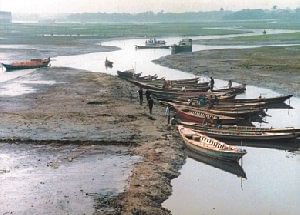
A CHOKED City ARTERY: Once a mighty river and the prime lifeline for the capital, the Buriganga has now reduced to a mere canal, as was seen at Basila yesterday. PHOTO: STAR |
