Combatting the north-eastern flood
Altafur Rahman
This year nature did not spare Bangladesh like it had in the past few flood free years. The flood water played havoc with millions of lives when around 700 people died and 10 million became homeless. The country sustained staggering losses in terms of damage to agriculture, destruction of homes, death of livestock, damage to infrastructure such as roads, rail tracks and electric towers. The preliminary flood damage this year is estimated around US $7 billion. Needless to say the human misery and sufferings that accompanied the flood heightened even after the water receded.Absence of mega rivers
It has been noticed that in the north eastern districts, bordering India, there is an absence of mega rivers. The flood water coming across the border has to travel a long distance to discharge into the mighty Meghna or upstream Bailai, Surma and Kushyiara or old Brahmnaputra river. The old Brahmaputra that branches out of the Jamuna (also known as main Brahmaputra) meanders through the greater Mymenshing district. Instead of draining waters of the north eastern catchments during the flood season, it brings more water from the Jamuna (main Brahmaputra) delaying the discharge of the receding flood water from Sunamganj and Sylhet area. It is imperative that whatever small and big rivers that exist in this north eastern area must be dredged regularly. Also all the Haors (wet land and watersheds), canals, tanks must be excavated periodically. Many of the rivers in this region criss- crosse the east-west plane rather than the north-south path, thus blocking water instead of draining it. If a barrage on the old Brahmaputa could be constructed, it could close the water intake of the main Brahamaputra (during flood barrage gates can be kept open unless they are built strong enough to withstand the flood water) during the flood season. This would not only improve the drainage of flood water from the north-eastern area, but would also divert the flood water of main Brahamaputra river from getting into this region already worsened by flood waters. Almost every year, the water bodies get filled up to the brim. There is hardly any safety margin left between the water line and dry land to prevent flooding. This safety margin needs to be increased by dredging or raising the earth floor or by constructing dikes. There is also the need to maintain balance between dry land and low flood plains so that flood water can be accommodated and drained out in time. In Dhaka City and its surrounding areas the ratio between dry land and flood plains has been upset to a dangerous level, because of earth filling due to increasing demand for housing for a rising population. To offset this change the government may relax the building height restriction to allow construction of tall buildings to accommodate the ever increasing population. The reasons for the recurrent floods are heavy rainfalls in the catchments due to global warming and consequently the "el nino" and "la lina" phenomena causing natural silltation of river beds and of flood plains. Other reasons are earth tremors, denudation of trees, increasing surface water and soil run off, change of course, river erosion, tidal changes, change in wind directions, sea level rise, syncronisation of flood in the Padma, Jamuna and Meghna rivers, accretion of land within rivers due to reduced water flow, lack of land use zoning, filling of low lands and hampering of water drainage by unplanned infrastructures etc. It is worth question why the incidence of flooding has increased globally in recent years. It seems we are caught in a vicious circle of global warming leading to more rain, more flood, deforestation, more surface and silt run off, more siltation of rivers, more flooding. Flood protection
There is a sharp division of opinion on the use of appropriate measures for flood protection, including river training to confine rivers, construction of embankments along rivers to contain flood water, dredging silted rivers to enhance its water retention capacity, widening flood plains to lower the impact, constructing dams to store flood water, transferring inter basin water to reduce water excavation of Haors and watersheds etc. No single measure can control floods in such a large environmental system in Bangladesh covering the deltaic formation created by the confluence of three of the mightiest rivers on the planet. The government is yet to reach a decision on a national flood protection programme although it has chartered a National Water Policy and approved the National Water Management Plan. The former emphasises on measures like embankment and dredging. The later has set out 64 programmes for implementation across the country. These include structural flood control measures such as construction of embankments and dredging and non-structural measures such as aforestation and flood proofing that requires rising of ground level of homesteads. At present flood protection measures are taken on ad hoc basis. In the existing budget, Tk 1,132 crores has been allocated for water development. The government should double or rather triple the budget allocation and implement a nation wide flood protection programme. The Flood Action Plan (FAB), especially about controlled flooding, did not get general public endorsement. Although much comprehensive studies have been conducted and pilot projects undertaken for flood mitigation. It is also not possible to control floods with the effort of one or two authorities. This is because each year the origination of flood, its area, quantum, duration, intensity, impact may differ making it a multi sectoral challange. Floods have to be tackled in all of its form, at every tier, and at every opportunity. Independent body
At present mainly Bangladesh Water Development Board (BWDB) together with Local Government Engineering Department (LGED) is engaged in flood protection measures, BWDB is a large organisation and it is entrusted with, apart from flood control measures, the construction of irrigation structures, management of river erosion, and land reclamation, which in themselves are huge tasks. The government must entrust flood control measures to an autonomous authority, which will be solely devoted to tackle this challenge. Such an independent organisation will be more effective and efficient than any government body. The government should also consider deployment of army engineers for flood protection measures. The engineers of Bangladesh Army have constructed the Marine Drive in Cox's Bazar, they could also participate in the construction of anti-flood measures. In the USA the army engineers were engaged in containing floods of the Mississippi river in 1993. Dredging
Both public and private initiatives should be utilised in controlling floods. The government, while constructing embankments or raising the height of already constructed embankments, should do so by dredging rivers instead of digging the nearby land. Private dredging boats could complement the government ones. Indigenous dredger boats are used to collect sand from river beds on a commercial basis for mainly the construction industry. These boats could be utilised to remove sand from river beds as a planned control measure and also their dredging capacity could be fitted into a well drawn flood mitigation plan. In winter, many of the rivers usually dry up or have little water flow. This is the time when river beds could be excavated to enlarge the river's water holding capacity. Floods must also be fought at the individual, family, community, local authority, national, regional and international level. An individual can help by planting trees, a family can join hands with other families to raise the earth wall around their houses, a community can think and come up with ways of how to protect the plinth of the shared homesteads, the local authority can initiate canal digging, nationally the government can implement costly flood control programmes, regionally advanced flood warning processes can be set up, and internationally long term impacts on floods, due to global warming and consequently sea level rise, must be studied and tackled. It seems that for the floods in Bangladesh, the Capital Hill and the White House are as much responsible as Bangabhavan. The clamping of the emission of carbon dioxide (the chief culprit for global warming), by the energy industry in USA, would go a long way to reduce global warming. Similarly, the Bangladesh government's implementation of forestation and other flood control measures could ease the intensity and extent of flooding. However, it seems the US government, for now at least, is satisfied with handing out flood aid rather than restricting its ever growing industry to cut on gas emission. Flood shelter
During the present flood crisis, the water rose to a level where people had to take shelter on higher grounds such as embankments, schools, government buildings, highways. In some places, people were seen taking shelter on trucks stranded in water on roads and highways. Many people had to walk long distances to find a dry place. These shelters were far and few. Flood shelters, like the cyclone shelters built in the coastal areas, should be constructed especially in the most flood prone places across the country. Such shelters should have adequate sanitary facilities in order to stop the outbreak of diarrhea and cholera, a common aftermath of flood. This year the flood has taken such a mega scale that even Sylhet city and smaller towns of the eastern region were not spared. The Sylhet city lacked defenses against such a massive flooding. The river Kushiyara despite having fairly high earth walls in some places, lacks wide flood plains and flows dangerously too close to Sylhet town. So when this river overflows, it deluges Sylhet. Sylhet city is also highly vulnerable to floods from the flood plains in the north. As a matter of fact recently the entire north eastern region was under chest deep water. There was no dry spot around to bury dead bodies. If flood shelters cannot be constructed above flood levels, it too would be flooded. To overcome this drawback the government should either construct stilt buildings or build steel barges like those towed by tugs or steamers in the inland waterways. These could become useful flood shelters as these would float irrespective of the level of the flood water. Barges could be placed in the Haor area where there is no high land. If necessary, they could be constructed two storey high to accommodate more people. These barges, if properly maintained, could have a life of 100 years utilising them as makeshift schools and hospitals during normal times. It is hoped that in the next Parliament session, flood protection measures will be given outmost importance, and members of both the government and the opposition party will equally participate to come up with permanent solutions to fight the menacing floods. Shouldn't they?
|
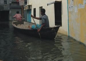
Flooded locality: Heightened misery |
