Tech Focus
Facing the flood wars with foresight
Manisha Gangopadhyay
TO predict oncoming floods, the Bangladesh Water Development Board's (BWDB) Flood Forecasting and Warning Centre (FFWC) uses a state-of-the art modeling software called Mike-11. The one-dimensional fully hydrodynamic model, MIKE 11 HD incorporates all major rivers and floodplains in Bangladesh. This is linked to a lumped conceptual rainfall-runoff model (MIKE 11 RR), which generates inflows from catchments within the country. There are a total of 216 catchment areas. The total length of modelled rivers is 7270 km.The primary information used in the Mike-11 flood prediction models is rainfall data and river water level. FFWC collect this data from 45 water stations and 54 rainfall stations, of which 14 are telemetric stations, located in high flood-prone areas. These stations collect rainfall data in real-time, in other words, every day, sometimes 2-3 times per day and in case of an emergency, every hour. Collecting river water level data is a bit tricky because 92% of the 1.7 thousand square mile catchment area is outside the country. The FFWC uses information from 14 locations in India and China to make an estimate of the water level at the border for our model. However, they are not currently in a position to extend their model beyond the border for lack of a standardised measurement system. The lead-time could be lengthened by 5-7 days if upstream information from India on the Brahmaputra river from the Allehebad and Putna points could be incorporated into the model. This year, executive engineer of FFWC, Salim Bhuiyan, was invited to be on the Joint Commission of Farakkha, which should bode well for sharing of information on river data. Other data inputs used in the flood modelling system are temperature, soil moisture, soil water level, ground water level, among others. After all data is inputted manually, the model is run and flood maps are generated from the results via a Geographical Information Systems (GIS) link to the model (MIKE 11 GIS), based on a standardised ranking system of flooding disaster. The model results are competent for forecasting up to 72 hours in advance with 95% accuracy, after which the accuracy level drops to 80%. Model results are then uploaded to the FFWC website and sent to The Disaster Management Bureau, various related government bodies, news agencies, and international relief organisations. To increase the lead time of predictions FFWC need to improve their rainfall quantity forecast information, technically known as Quantitative Precipitation Forecast (QPF). To get this information, our national weather forecasters would require a Doppler system or satellite pictures, which it does not have. QPF is used in the conceptual rainfall-runoff model (NAM Model) to generate runoff information. Since the floods of 1998, the FFWC has developed a Digital Elevation Model (DEM) to calculate the depth and extent of inundation based on topographic information, water level forecasts and GIS-based analysis. One weakness of the system, which should soon be mitigated, is that the topographic maps used in the model is based on a survey carried out in 1956 by the Survey of Bangladesh (SOB). Since then, drainage systems have been updated and infrastructure across the country has been added, removed and changed. The FFWC get around this by carrying out its own surveys and using their own knowledge of the areas (in Dhaka they have personally surveyed the Balu River area). However, they do not have the capacity to execute full or accurate coverage without an extensive study. Currently, the SOB is developing a topographic map of Dhaka to be released in 2005, which may be provided in electronic format to government bodies. Unfortunately, the absence of a nationwide communication link to micro-level government bodies, namely the Upazilas, poses an obstacle to widespread dissemination of flood forecasts, particularly village interiors, where flood damage and devastation hits the hardest. What you have is the technological advancements in FFWC meeting an antiquated communication network. "If this had been an industrialised country, flood warning could be widely broadcasted through the internet. In Bangladesh we do not have that advantage," laments Salim Bhuiya. More information on flood forecasting is available at the FFWC website, www.ffwc.net. There is a Mike-11 simulation on the site. One can also avail water level forecasts of individual monitoring stations located in different parts of the country.
|
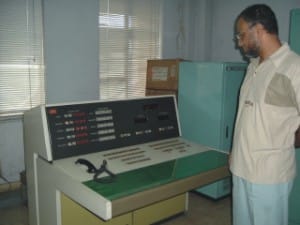
Salim Bhuiya looks at the Telemetry Receiver Switchboard at the FFWC |
